IMAGES TAKEN NEAR TO
High Hoe Court, WORKSOP, S80 2PJ
Introduction
This page details the photographs taken nearby to High Hoe Court, S80 2PJ by members of the Geograph project.
The Geograph project started in 2005 with the aim of publishing, organising and preserving representative images for every square kilometre of Great Britain, Ireland and the Isle of Man.

There are currently over 7.5m images from over14,400 individuals and you can help contribute to the project by visiting https://www.geograph.org.uk
Image Map
Images are licensed for reuse under creativecommons.org/licenses/by-sa/2.0
Notes
- Clicking on the map will re-center to the selected point.
- The higher the marker number, the further away the image location is from the centre of the postcode.
Image Listing (88 Images Found)
Images are licensed for reuse under creativecommons.org/licenses/by-sa/2.0
Image
Details
Distance
1
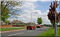
High Hoe Road Worksop
See the horse and cart Hi Ho silver!
Image: © Steve Fareham
Taken: 14 May 2008
0.03 miles
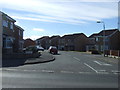
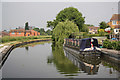
4

Worksop - Canal View near Bracebridge
Image: © Alan Heardman
Taken: 13 Nov 2008
0.05 miles
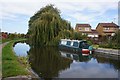
5
Chesterfield Canal
View upstream from Bracebridge lock
Image: © Richard Croft
Taken: 5 Jun 2010
0.06 miles
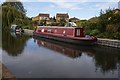
6
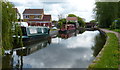
Narrowboats moored along the Chesterfield Canal
Next to Bracebridge Lock No 51 in Worksop.
Image: © Mat Fascione
Taken: 22 May 2016
0.06 miles
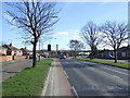
8
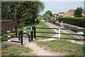
Bracebridge lock
Anti-motorbike measures guarding the access to the Chesterfield Canal towpath and NCN route 6 at Bracebridge lock
Image: © Richard Croft
Taken: 5 Jun 2010
0.07 miles
9
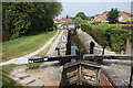
Bracebridge lock
Lock number 51 on The Chesterfield Canal
Image: © Richard Croft
Taken: 5 Jun 2010
0.08 miles