IMAGES TAKEN NEAR TO
Hardwick Road West, WORKSOP, S80 2NN
Introduction
This page details the photographs taken nearby to Hardwick Road West, S80 2NN by members of the Geograph project.
The Geograph project started in 2005 with the aim of publishing, organising and preserving representative images for every square kilometre of Great Britain, Ireland and the Isle of Man.

There are currently over 7.5m images from over14,400 individuals and you can help contribute to the project by visiting https://www.geograph.org.uk
Image Map
Images are licensed for reuse under creativecommons.org/licenses/by-sa/2.0
Notes
- Clicking on the map will re-center to the selected point.
- The higher the marker number, the further away the image location is from the centre of the postcode.
Image Listing (28 Images Found)
Images are licensed for reuse under creativecommons.org/licenses/by-sa/2.0
Image
Details
Distance
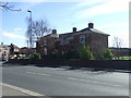
2
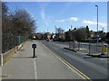
Manton by Hardwick road east
Looking away from Worksop towards Retford.
Image: © roger geach
Taken: 17 Jan 2011
0.08 miles
3
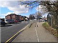
Shrewsbury Road
Looking south on National Cycle Route 6.
Image: © JThomas
Taken: 16 Mar 2014
0.09 miles
4
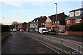
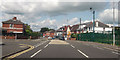
Take Away Shops at Manton
Looking towards Worksop Town centre , Manton is on the outskirts and once had a mine at Manton Wood.
Image: © roger geach
Taken: 17 Jan 2011
0.10 miles
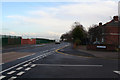
5
Dual purpose path beside Retford Road
Heading east.
Image: © JThomas
Taken: 16 Mar 2014
0.11 miles
6
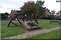
Memorial to Manton Colliery (1898-1994)
For history of colliery: http://priorieshistoricalsociety.btck.co.uk/WorksopLife/CoalMining
Image: © Tim Heaton
Taken: 5 Oct 2013
0.11 miles
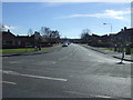
8
Retford Road at Hardwick Road east junction
Opposite recreation ground
Image: © John Firth
Taken: 19 Jun 2012
0.15 miles
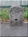
9
Milestone
Old Milestone on the B6040 at Worksop, Nottinghamshire. For close up view see http://www.geograph.org.uk/photo/4595207
Image: © Keith Evans
Taken: 20 Jun 2015
0.17 miles
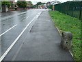
10
Old Milestone by the B6040, Retford Road, Worksop
Stone post (plate lost) by the B6040, in parish of Worksop (Bassetlaw District), Retford Road; by Manton Colliery Club, in pavement, in front of wire fence surrounding Manton Colliery Club Sports Ground, on North side of road. Retford iron plate, erected by the Worksop to Retford turnpike trust in the 19th century.
Inscription once read:-
(RETFORD)
(7)
(WORKSOP)
(1)
Carved benchmark on left side.
Milestone Society National ID: NT_RFWK07
Image: © MW Hallett & C Minto
Taken: 8 Sep 2003
0.19 miles