IMAGES TAKEN NEAR TO
Cheapside, WORKSOP, S80 2JJ
Introduction
This page details the photographs taken nearby to Cheapside, S80 2JJ by members of the Geograph project.
The Geograph project started in 2005 with the aim of publishing, organising and preserving representative images for every square kilometre of Great Britain, Ireland and the Isle of Man.

There are currently over 7.5m images from over14,400 individuals and you can help contribute to the project by visiting https://www.geograph.org.uk
Image Map
Images are licensed for reuse under creativecommons.org/licenses/by-sa/2.0
Notes
- Clicking on the map will re-center to the selected point.
- The higher the marker number, the further away the image location is from the centre of the postcode.
Image Listing (132 Images Found)
Images are licensed for reuse under creativecommons.org/licenses/by-sa/2.0
Image
Details
Distance
1
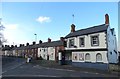
"The Manton Inn", Worksop
Sadly, there are signs that this pub may have ceased trading.
Image: © Neil Theasby
Taken: 9 Feb 2016
0.05 miles
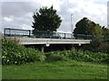
2
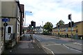
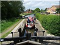
Cycle Route 6 crossing Cheapside (B6040), Worksop
Image: © Tim Heaton
Taken: 5 Oct 2013
0.06 miles
4
Memorial to Manton Colliery (1898-1994)
For history of colliery: http://priorieshistoricalsociety.btck.co.uk/WorksopLife/CoalMining
Image: © Tim Heaton
Taken: 5 Oct 2013
0.14 miles
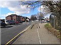
6
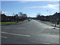
Shrewsbury Road
Looking south on National Cycle Route 6.
Image: © JThomas
Taken: 16 Mar 2014
0.16 miles
7
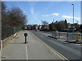
Dual purpose path beside Retford Road
Heading east.
Image: © JThomas
Taken: 16 Mar 2014
0.16 miles
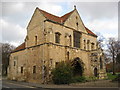
10
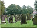
Gravestones east of Worksop Priory Church
Like many other old churchyards, this one has some beautiful trees.
Image: © Christine Johnstone
Taken: 12 Oct 2011
0.18 miles