IMAGES TAKEN NEAR TO
Boundary Row, WORKSOP, S80 2HH
Introduction
This page details the photographs taken nearby to Boundary Row, S80 2HH by members of the Geograph project.
The Geograph project started in 2005 with the aim of publishing, organising and preserving representative images for every square kilometre of Great Britain, Ireland and the Isle of Man.

There are currently over 7.5m images from over14,400 individuals and you can help contribute to the project by visiting https://www.geograph.org.uk
Image Map
Images are licensed for reuse under creativecommons.org/licenses/by-sa/2.0
Notes
- Clicking on the map will re-center to the selected point.
- The higher the marker number, the further away the image location is from the centre of the postcode.
Image Listing (234 Images Found)
Images are licensed for reuse under creativecommons.org/licenses/by-sa/2.0
Image
Details
Distance
1
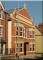
Former Boundary Inn, Potter Street
Late Victorian public house, now converted to a house. The boundary referred to may well be that between Worksop and the village of Radford, the two being the communities centred respectively on the castle and the priory.
Image: © Alan Murray-Rust
Taken: 4 Oct 2015
0.03 miles
2
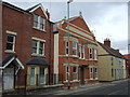
Former Boundary Inn, Worksop
On Potter Street.
Now converted.
Image: © JThomas
Taken: 17 Mar 2014
0.03 miles
3
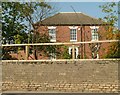
The Old Vicarage, Potter Street
Late 18th century house, later converted to offices, as part of the Victoria Hospital. Listed Grade II.
Image: © Alan Murray-Rust
Taken: 4 Oct 2015
0.04 miles
4
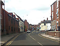
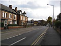
Potter Street approaching Watson Street junction
Image: © John Firth
Taken: 19 Jun 2012
0.05 miles
5
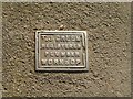
Water stop-tap cover
These usually carry the name of the water supply company, but I noticed a number of these when walking round the town.
Image: © Alan Murray-Rust
Taken: 4 Oct 2015
0.06 miles
6

Colourful flower border at the junction of Potter Street and Watson Road, Worksop
Image: © Colin Park
Taken: 2 Aug 2011
0.06 miles
7
Worksop - Watson Road junction with Newcastle Street
Image: © Alan Heardman
Taken: 11 Nov 2008
0.07 miles
8
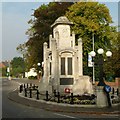
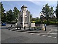
Worksop Town War Memorial
Built 1925, designed by local Architect A H Richardson. It stands in an island in the middle of Memorial Avenue, which was constructed at the same time. The Avenue, Monument, Victoria Hospital Memorial wing (now demolished) and the restored Lady Chapel of the Priory Church must form one of the most extensive memorial groups in the country. The Monument is Listed Grade II*.
The dwarf brick wall to the rear is Listed Grade II as part of the former Central Library.
Image: © Alan Murray-Rust
Taken: 4 Oct 2015
0.07 miles
9
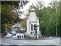
Worksop War Memorial
Seen from the west.
Image: © Christine Johnstone
Taken: 12 Oct 2011
0.07 miles
10
First World War Memorial, Memorial Avenue, Worksop
Image: © Chris Morgan
Taken: 3 Sep 2012
0.07 miles