IMAGES TAKEN NEAR TO
Canal Road, WORKSOP, S80 2EH
Introduction
This page details the photographs taken nearby to Canal Road, S80 2EH by members of the Geograph project.
The Geograph project started in 2005 with the aim of publishing, organising and preserving representative images for every square kilometre of Great Britain, Ireland and the Isle of Man.

There are currently over 7.5m images from over14,400 individuals and you can help contribute to the project by visiting https://www.geograph.org.uk
Image Map
Images are licensed for reuse under creativecommons.org/licenses/by-sa/2.0
Notes
- Clicking on the map will re-center to the selected point.
- The higher the marker number, the further away the image location is from the centre of the postcode.
Image Listing (215 Images Found)
Images are licensed for reuse under creativecommons.org/licenses/by-sa/2.0
Image
Details
Distance
1
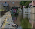
Chesterfield Canal in Worksop
The narrowboat is moored near the Straddle Warehouse.
Image: © Mat Fascione
Taken: 22 May 2016
0.02 miles
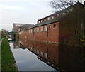
2
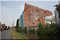
Albion Mill
Flour mill beside the Chesterfield Canal in Worksop
Image: © Richard Croft
Taken: 5 Jun 2010
0.02 miles
3
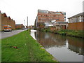
Worksop - Chesterfield Canal and Canal Road
Image: © Alan Heardman
Taken: 11 Nov 2008
0.03 miles
6
Factories beside the canal in Worksop
Cuckoo Way.
Image: © steven ruffles
Taken: 22 Nov 2011
0.04 miles
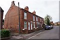
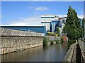
7
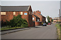
Canal Road
Road by the Chesterfield Canal through Worksop
Image: © Richard Croft
Taken: 5 Jun 2010
0.04 miles
8
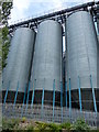
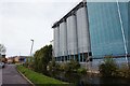
Silos next to the Chesterfield Canal
Part of Albion Mill, owned by Smiths Flour Mills.
Image: © Mat Fascione
Taken: 22 May 2016
0.04 miles
9
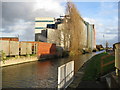
The Chesterfield Canal
Looking eastwards towards Whitworth Bros (formerly Smith's) flour mill.
Image: © Jonathan Thacker
Taken: 8 Jul 2016
0.05 miles