IMAGES TAKEN NEAR TO
Potter Street, WORKSOP, S80 2BZ
Introduction
This page details the photographs taken nearby to Potter Street, S80 2BZ by members of the Geograph project.
The Geograph project started in 2005 with the aim of publishing, organising and preserving representative images for every square kilometre of Great Britain, Ireland and the Isle of Man.

There are currently over 7.5m images from over14,400 individuals and you can help contribute to the project by visiting https://www.geograph.org.uk
Image Map
Images are licensed for reuse under creativecommons.org/licenses/by-sa/2.0
Notes
- Clicking on the map will re-center to the selected point.
- The higher the marker number, the further away the image location is from the centre of the postcode.
Image Listing (163 Images Found)
Images are licensed for reuse under creativecommons.org/licenses/by-sa/2.0
Image
Details
Distance
2
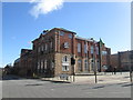
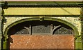
Worksop Town Hall
Built in 1851 as the Corn Exchange, it was purchased in 1882 by the Local Board of Health which became Worksop Urban District Council in 1894, whereupon it became the Town Hall. There was originally a flight of steps up to doors in the 3 central openings, but these were removed when the new council offices were built and access to the hall is now through these. The palladian style window in the side wall is a modern insertion replacing number of non-original windows. Listed Grade II. There is a flush bracket bench mark http://www.geograph.org.uk/photo/4690645 below the right hand window of the main façade.
Image: © Alan Murray-Rust
Taken: 4 Oct 2015
0.01 miles
3
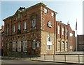
Worksop - Town Hall
Formerly, the Corn Exchange. See page 12 of http://www.worksopheritagetrail.org.uk/resources/worksop_history_4.pdf for more information on the building's history. For an alternative view, please see Image
Image: © Dave Bevis
Taken: 4 Jan 2013
0.01 miles
4
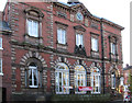
Former 18th century houses on Potter Street
Now incorporated into the Bassetlaw Council Offices (Queen's Buildings). The ground floors have been completely rebuilt as part of this conversion but in any case the ground floor frontages had already been replaced by later shop fronts. Both are Listed Grade II.
Image: © Alan Murray-Rust
Taken: 4 Oct 2015
0.01 miles
5
Here be dragons, on the French Horn Hotel
A fine terracotta pair in the spandrels of the bar room window.
Image: © Alan Murray-Rust
Taken: 4 Oct 2015
0.01 miles
6
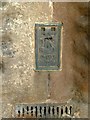
Flush Bracket bench mark, Worksop Town Hall
See http://www.geograph.org.uk/photo/4690631 for location.
Image: © Alan Murray-Rust
Taken: 4 Oct 2015
0.01 miles
7
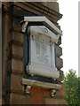
War Memorial on the Town Hall
Memorials commemorating the dead of the Boer War in South Africa are relatively uncommon.
Image: © Alan Murray-Rust
Taken: 4 Oct 2015
0.01 miles
8
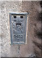
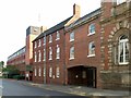
Ordnance Survey Flush Bracket (S0493)
This OS Flush Bracket can be found on the north face of the Town Hall. It marks a point 41.330m above mean sea level.
Image: © Adrian Dust
Taken: 25 May 2016
0.01 miles

10
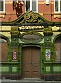
The French Horn, Potter Street
The main entrance in two-tone green faience.
Image: © Alan Murray-Rust
Taken: 4 Oct 2015
0.01 miles