IMAGES TAKEN NEAR TO
Queen Street, WORKSOP, S80 2AN
Introduction
This page details the photographs taken nearby to Queen Street, S80 2AN by members of the Geograph project.
The Geograph project started in 2005 with the aim of publishing, organising and preserving representative images for every square kilometre of Great Britain, Ireland and the Isle of Man.

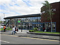
There are currently over 7.5m images from over14,400 individuals and you can help contribute to the project by visiting https://www.geograph.org.uk
Image Map
Images are licensed for reuse under creativecommons.org/licenses/by-sa/2.0
Notes
- Clicking on the map will re-center to the selected point.
- The higher the marker number, the further away the image location is from the centre of the postcode.
Image Listing (229 Images Found)
Images are licensed for reuse under creativecommons.org/licenses/by-sa/2.0
Image
Details
Distance
1
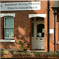
An independent Bassetlaw?
Perhaps following in the footsteps of the republic of South Yorkshire? In fact what is offered is a more independent lifestyle for homeless and vulnerable people in the district under the Framework banner.
Image: © Alan Murray-Rust
Taken: 4 Oct 2015
0.02 miles
2
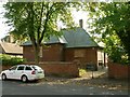
Former telephone exchange
Built 1939, with later extensions, in red brick with Westmorland slate roof, Listed Grade II. When listed in 2002 it housed the museum of the Institute of British Telecom Engineers' museum, including some original switching equipment, but the museum had to close for financial reasons and the building is currently unused.
Image: © Alan Murray-Rust
Taken: 4 Oct 2015
0.04 miles
3
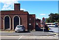
Watson Road, Worksop, Notts.
A redundant Health Clinic opposite the eastern elevation of a large ASDA supermarket and adjacent to the rear of the new (2015) Bus Station. An elderly gentleman whom I spoke to recalled attending the clinic for a B.C.G inoculation as a youngster. Apparently it is unused at present.
Image: © David Hallam-Jones
Taken: 8 Sep 2016
0.04 miles
4
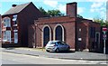
Watson Road, Worksop, Notts.
A redundant Health Clinic opposite the eastern elevation of a large ASDA supermarket and adjacent to the rear of the new (2015) Bus Station. An elderly gentleman whom I spoke to, recalled attending the clinic for a B.C.G inoculation as a youngster. Apparently it is unused at present.
Image: © David Hallam-Jones
Taken: 8 Sep 2016
0.05 miles
5
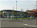
Worksop Bus Station
Opened August 2015.
Image: © Jonathan Thacker
Taken: 8 Jul 2016
0.06 miles
6
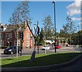
Bus Station Vicinity, Worksop, Notts.
The Worksop Civic Society, with the aid of a grant from the county council’s Supporting Local Communities Fund, worked with a number of Level 3 Art and Design students from North Nottingham College - over a two year period - to create and design this tree-like sculpture. The sculpture was installed outside the pedestrian entrance to the new £3.2m bus station on 31st July 2015. The red car appears to have passed the new (2010) round-shaped library in Memorial Avenue, whilst the blue vehicle is entering Newcastle Street. Watson Road can also be seen at this crossroad.
Image: © David Hallam-Jones
Taken: 8 Sep 2016
0.06 miles
7
Worksop Bus Station
This opened at the end of August 2015 replacing the bus stands located on Hardy Street http://www.geograph.org.uk/photo/3022054
Image: © Alan Murray-Rust
Taken: 4 Oct 2015
0.06 miles
8
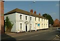
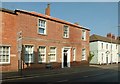
39 and 41 Potter Street
Late 18th century houses, built as a unit. Now converted to offices. Listed Grade II.
Image: © Alan Murray-Rust
Taken: 4 Oct 2015
0.07 miles
9
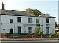
Quorn House, Watson Road
Late 18th century house, partly converted from industrial use, later converted to offices, currently unoccupied. Listed Grade II.
Image: © Alan Murray-Rust
Taken: 4 Oct 2015
0.07 miles
10
37 Potter Street
Early 19th century house, now converted to offices. Listed Grade II.
Image: © Alan Murray-Rust
Taken: 4 Oct 2015
0.07 miles