IMAGES TAKEN NEAR TO
The Croft, Potter Street, WORKSOP, S80 2AF
Introduction
This page details the photographs taken nearby to The Croft, Potter Street, S80 2AF by members of the Geograph project.
The Geograph project started in 2005 with the aim of publishing, organising and preserving representative images for every square kilometre of Great Britain, Ireland and the Isle of Man.

There are currently over 7.5m images from over14,400 individuals and you can help contribute to the project by visiting https://www.geograph.org.uk
Image Map
Images are licensed for reuse under creativecommons.org/licenses/by-sa/2.0
Notes
- Clicking on the map will re-center to the selected point.
- The higher the marker number, the further away the image location is from the centre of the postcode.
Image Listing (220 Images Found)
Images are licensed for reuse under creativecommons.org/licenses/by-sa/2.0
Image
Details
Distance
1
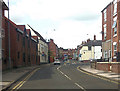
Potter Street approaching Watson Street junction
Image: © John Firth
Taken: 19 Jun 2012
0.02 miles
2

Colourful flower border at the junction of Potter Street and Watson Road, Worksop
Image: © Colin Park
Taken: 2 Aug 2011
0.02 miles
3
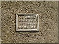
Water stop-tap cover
These usually carry the name of the water supply company, but I noticed a number of these when walking round the town.
Image: © Alan Murray-Rust
Taken: 4 Oct 2015
0.02 miles
4
Worksop - offices on Potter Street
Near Watson Road junction. For an alternative view, please see Image
Image: © Dave Bevis
Taken: 4 Jan 2013
0.03 miles
5
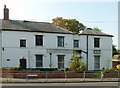
Quorn House, Watson Road
Late 18th century house, partly converted from industrial use, later converted to offices, currently unoccupied. Listed Grade II.
Image: © Alan Murray-Rust
Taken: 4 Oct 2015
0.04 miles
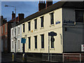
6
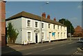
39 and 41 Potter Street
Late 18th century houses, built as a unit. Now converted to offices. Listed Grade II.
Image: © Alan Murray-Rust
Taken: 4 Oct 2015
0.04 miles
7
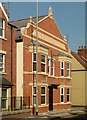
Former Boundary Inn, Worksop
On Potter Street.
Now converted.
Image: © JThomas
Taken: 17 Mar 2014
0.05 miles
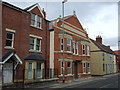
8
Former Boundary Inn, Potter Street
Late Victorian public house, now converted to a house. The boundary referred to may well be that between Worksop and the village of Radford, the two being the communities centred respectively on the castle and the priory.
Image: © Alan Murray-Rust
Taken: 4 Oct 2015
0.05 miles
9
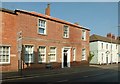
37 Potter Street
Early 19th century house, now converted to offices. Listed Grade II.
Image: © Alan Murray-Rust
Taken: 4 Oct 2015
0.05 miles
10

38 Potter Street
Early 19th century 5 bay house, now converted to offices. Listed Grade II.
Image: © Alan Murray-Rust
Taken: 4 Oct 2015
0.06 miles