IMAGES TAKEN NEAR TO
Alderson Road, WORKSOP, S80 1UZ
Introduction
This page details the photographs taken nearby to Alderson Road, S80 1UZ by members of the Geograph project.
The Geograph project started in 2005 with the aim of publishing, organising and preserving representative images for every square kilometre of Great Britain, Ireland and the Isle of Man.

There are currently over 7.5m images from over14,400 individuals and you can help contribute to the project by visiting https://www.geograph.org.uk
Image Map
Images are licensed for reuse under creativecommons.org/licenses/by-sa/2.0
Notes
- Clicking on the map will re-center to the selected point.
- The higher the marker number, the further away the image location is from the centre of the postcode.
Image Listing (55 Images Found)
Images are licensed for reuse under creativecommons.org/licenses/by-sa/2.0
Image
Details
Distance
1
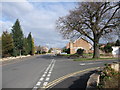
Almond Grove joining Robinson Drive, Worksop
Image: © Tim Heaton
Taken: 22 Feb 2009
0.02 miles
2
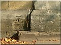
Bench Mark, St Mary's Churchyard wall
See http://www.geograph.org.uk/photo/4691379 for location.
Image: © Alan Murray-Rust
Taken: 4 Oct 2015
0.08 miles
3
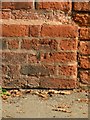
Bench mark, Sparken Hill
See http://www.geograph.org.uk/photo/4691390 for location.
Image: © Alan Murray-Rust
Taken: 4 Oct 2015
0.09 miles
4
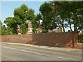
Sherwood House, Sparken Hill
This house, rather hidden behind its high wall and the trees, was built around 1850 for the estate manager of Worksop Manor. The architect is thought to be T C Hine of Nottingham. The size of the house indicates that estate manager was a prestigious post to hold. There is a bench mark http://www.geograph.org.uk/photo/4691386 on the pier at the right.
Image: © Alan Murray-Rust
Taken: 4 Oct 2015
0.09 miles
5
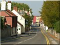
Park Street
This was traditionally the main entry to the town from the south. The new Savoy Cinema forms a significant visual stop to the vista.
Image: © Alan Murray-Rust
Taken: 4 Oct 2015
0.09 miles
7
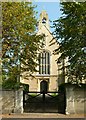
Church of St Mary, Park Street
Roman Catholic Church, built in 1838 for the Duke of Norfolk, an adherent to the Catholic faith. Listed Grade II. This is the entrance off Park Street. There is a bench mark http://www.geograph.org.uk/photo/4691380 on the wall to the left of the gateway.
Image: © Alan Murray-Rust
Taken: 4 Oct 2015
0.10 miles
8
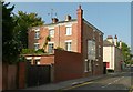
40 Park Street
Although not listed, this is an attractive early to mid 19th century house.
Image: © Alan Murray-Rust
Taken: 4 Oct 2015
0.10 miles
9
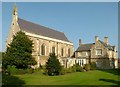
Church of St Mary, Park Street
Roman Catholic Church, built in 1838 for the Duke of Norfolk, an adherent to the Catholic faith. Designed by M E Hadfield in Perpendicular revival style, Listed Grade II. The attached presbytery does not form part of the listing.
Image: © Alan Murray-Rust
Taken: 4 Oct 2015
0.10 miles
10
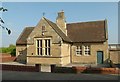
St Mary's Church School
Mid 19th century school for the Roman Catholic community, now church hall. Listed Grade II for group value.
Image: © Alan Murray-Rust
Taken: 4 Oct 2015
0.12 miles