IMAGES TAKEN NEAR TO
Overend Road, WORKSOP, S80 1QE
Introduction
This page details the photographs taken nearby to Overend Road, S80 1QE by members of the Geograph project.
The Geograph project started in 2005 with the aim of publishing, organising and preserving representative images for every square kilometre of Great Britain, Ireland and the Isle of Man.

There are currently over 7.5m images from over14,400 individuals and you can help contribute to the project by visiting https://www.geograph.org.uk
Image Map
Images are licensed for reuse under creativecommons.org/licenses/by-sa/2.0
Notes
- Clicking on the map will re-center to the selected point.
- The higher the marker number, the further away the image location is from the centre of the postcode.
Image Listing (181 Images Found)
Images are licensed for reuse under creativecommons.org/licenses/by-sa/2.0
Image
Details
Distance
1
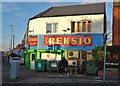
Polish convenience store on Gateford Road
Worksop is home to a significant Polish community and there are several Polish businesses in this part of the town.
Image: © Neil Theasby
Taken: 10 Jan 2020
0.01 miles
2
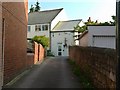
Entrance to the Sea Cadets
There is a bench mark http://www.geograph.org.uk/photo/4690020 on the right hand wall.
Image: © Alan Murray-Rust
Taken: 4 Oct 2015
0.03 miles
3
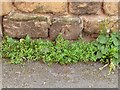
Bench Mark, Gateford Road
See http://www.geograph.org.uk/photo/4690022 for location.
Image: © Alan Murray-Rust
Taken: 4 Oct 2015
0.03 miles
4
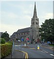
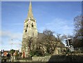
Gatefold Road, Worksop, Notts.
St John’s Church on Gatefold Road (i.e. the B6040) from Sandy Lane. It was built in Early English style by Charles Wright, a Nottingham builder, to a design by R Clarke & Son, also of Nottingham and amongst other features it boasts a 140 ft high broach spire. It was consecrated in August 1869.
Image: © David Hallam-Jones
Taken: 8 Sep 2016
0.04 miles
5
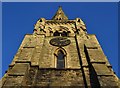
The tower of St John's Church, Worksop
Image: © Neil Theasby
Taken: 10 Jan 2020
0.05 miles
6
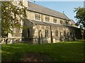
Church of St John, Gateford Road
Typical Victorian church for urban expansion, built 1868 in Decorated Revival style. The very restricted churchyard makes it difficult to photograph in its entirety. This is the south aisle. Listed Grade II.
There is a bench mark http://www.geograph.org.uk/photo/4690024 at the base of the tower at the left of the picture.
Image: © Alan Murray-Rust
Taken: 4 Oct 2015
0.05 miles
7
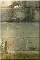
Bench mark, St John's Church
See http://www.geograph.org.uk/photo/4690026 for location.
Image: © Alan Murray-Rust
Taken: 4 Oct 2015
0.05 miles
8
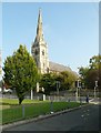
Church of St John, Gateford Road
View from Colbeck Street showing the elegant 140 ft tall spire. Listed Grade II.
Image: © Alan Murray-Rust
Taken: 4 Oct 2015
0.05 miles
9
St John's church, Worksop
Built 1860 https://historicengland.org.uk/listing/the-list/list-entry/1370402?section=official-list-entry
Image: © Jonathan Thacker
Taken: 3 Feb 2023
0.06 miles
10
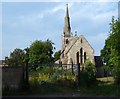
Calverton Road Vicinity, Worksop, Notts
The rear (east elevation) of St John’s parish church seen from the far end of a track opposite the former Council Offices building, near the railway station. The track serves a row of 6-7 terraced houses off Calverton Road. St John's, with its 140ft high broach spire, was consecrated in August 1869. The architect was R Clarke & Son of Nottingham and the builder, a certain Charles Wright, also of Nottingham.
Image: © David Hallam-Jones
Taken: 8 Sep 2016
0.07 miles