IMAGES TAKEN NEAR TO
Carlton Road, WORKSOP, S80 1PH
Introduction
This page details the photographs taken nearby to Carlton Road, S80 1PH by members of the Geograph project.
The Geograph project started in 2005 with the aim of publishing, organising and preserving representative images for every square kilometre of Great Britain, Ireland and the Isle of Man.

There are currently over 7.5m images from over14,400 individuals and you can help contribute to the project by visiting https://www.geograph.org.uk
Image Map
Images are licensed for reuse under creativecommons.org/licenses/by-sa/2.0
Notes
- Clicking on the map will re-center to the selected point.
- The higher the marker number, the further away the image location is from the centre of the postcode.
Image Listing (229 Images Found)
Images are licensed for reuse under creativecommons.org/licenses/by-sa/2.0
Image
Details
Distance
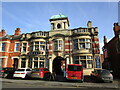
1
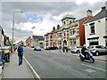
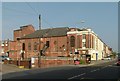
Worksop ex-council offices in Carlton Road
Now a bathroom and kitchen showroom
Image: © Chris Morgan
Taken: 30 Apr 2012
0.02 miles
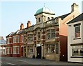
2
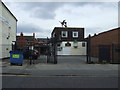
The Frog and Nightgown pub, Worksop
On Carlton Street.
Image: © JThomas
Taken: 17 Mar 2014
0.02 miles
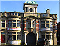
3
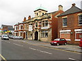
Worksop - Carlton Road
View of former Council Offices building.
Image: © Alan Heardman
Taken: 11 Nov 2008
0.02 miles
4
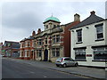
Council Offices, Worksop
On Carlton Street.
Image: © JThomas
Taken: 17 Mar 2014
0.02 miles
5
Former council offices, Carlton Road, Worksop
Built as Waterworks Offices in the 1890s and taken over by Worksop Urban District Council in 1909 https://historicengland.org.uk/listing/the-list/list-entry/1156341?section=official-list-entry
Image: © Jonathan Thacker
Taken: 3 Feb 2023
0.02 miles
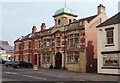
6
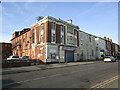
Worksop - former Council Offices
On Carlton Road. For an alternative view, please see Image
Image: © Dave Bevis
Taken: 4 Jan 2013
0.03 miles
7
Former Council Offices, Carlton Road
Built for Worksop Urban District Council around 1900. Currently occupied by a Vintage, Arts and Crafts Centre. Listed Grade II.
Image: © Alan Murray-Rust
Taken: 4 Oct 2015
0.03 miles
8
Carlton Road, Worksop, Notts.
This building that once housed the local Council Offices, currently hosts a number of small retail units including an antiques and collectables centre and a tea-shop. Worksop railway station is a 2-3 minute walk away on the photographer's left.
Image: © David Hallam-Jones
Taken: 8 Sep 2016
0.03 miles
9
The Regal, Carlton Road
Most urban cinemas are hemmed in by other buildings, but in this case the layout of the building with auditorium and fly tower is very clear. It was built in 1926 as the Miners' Welfare Hall, briefly becoming the Pavilion Cinema in 1929, then being rebuilt with fly tower in 1930 to become the Regal.
Converted into a 3-screen cinema in 1972, its final version from the 1990s saw the stalls area being used for live theatre with a cinema in the balcony, all under the Regal Centre name. In this form it closed in 2013 following the opening of the new Savoy Cinema.
Image: © Alan Murray-Rust
Taken: 4 Oct 2015
0.04 miles
10
The former Regal Cinema, Worksop
This building has had a chequered history http://cinematreasures.org/theaters/47911 and now looks to be in a poor state. It was once the grandest building in this part of town. Built in 1926 as the Miners'Welfare Pavilion.
Image: © Jonathan Thacker
Taken: 3 Feb 2023
0.04 miles