IMAGES TAKEN NEAR TO
Westgate, WORKSOP, S80 1LT
Introduction
This page details the photographs taken nearby to Westgate, S80 1LT by members of the Geograph project.
The Geograph project started in 2005 with the aim of publishing, organising and preserving representative images for every square kilometre of Great Britain, Ireland and the Isle of Man.

There are currently over 7.5m images from over14,400 individuals and you can help contribute to the project by visiting https://www.geograph.org.uk
Image Map
Images are licensed for reuse under creativecommons.org/licenses/by-sa/2.0
Notes
- Clicking on the map will re-center to the selected point.
- The higher the marker number, the further away the image location is from the centre of the postcode.
Image Listing (147 Images Found)
Images are licensed for reuse under creativecommons.org/licenses/by-sa/2.0
Image
Details
Distance
2

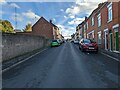
Worksop - Norfolk Street junction with Newcastle Avenue
Image: © Alan Heardman
Taken: 11 Nov 2008
0.04 miles
3
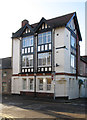
Worksop - former Norfolk Arms
On Norfolk Street.
Image: © Dave Bevis
Taken: 4 Jan 2013
0.04 miles
4
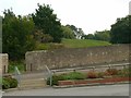
Nondescript grassy mound and enclosing wall
The mound is in fact the motte of the medieval castle of around 1100, and the site is a Scheduled Monument.
Image: © Alan Murray-Rust
Taken: 4 Oct 2015
0.07 miles
5
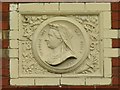
Queen Victoria's head
One of a pair of terracotta panels on Queens Terrace http://www.geograph.org.uk/photo/4690116 , built in 1897 and commemorating Victoria's Diamond Jubilee. Note the traditional flowers of England, Wales, Scotland and Ireland. The terracotta has been overpainted, but in this instance less detrimentally than is sometimes the case.
Image: © Alan Murray-Rust
Taken: 4 Oct 2015
0.07 miles
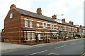
6
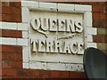
Queens Terrace
Terracotta panel on Queens Terrace http://www.geograph.org.uk/photo/4690116 , built in 1897 and commemorating Victoria's Diamond Jubilee. The terracotta has been overpainted, but in this instance less detrimentally than is sometimes the case.
Image: © Alan Murray-Rust
Taken: 4 Oct 2015
0.07 miles

8
Queens Terrace, Newcastle Avenue
The date 1897 occurs in 3 terracotta panels http://www.geograph.org.uk/photo/4690108 along the terrace showing that it was commemorating Queen Victoria's Diamond Jubilee.
Image: © Alan Murray-Rust
Taken: 4 Oct 2015
0.08 miles
9
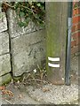
Bench mark, bridge parapet, Newcastle Avenue
This mark is larger than the typical mark, which identifies it as an early mark. On investigation, it turns out to be mark no.98 of the First primary levelling, England & Wales (1GL) line from Thorne to Stalybridge surveyed in 1845. http://www.bench-marks.org.uk/ew1gl/1GLA_348.png The original survey names the watercourse as the River Ryton, although in practice it is only a tributary stream. See http://www.geograph.org.uk/photo/4690124 for location.
Image: © Alan Murray-Rust
Taken: 4 Oct 2015
0.09 miles
10
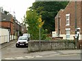
Bridge on Newcastle Avenue at Brook Terrace
The parapet dates from the reconstruction of the road by the Duke of Newcastle in about 1842. There is an early bench mark http://www.geograph.org.uk/photo/4690121 just by the telegraph pole.
Image: © Alan Murray-Rust
Taken: 4 Oct 2015
0.09 miles