IMAGES TAKEN NEAR TO
Lead Hill, WORKSOP, S80 1LJ
Introduction
This page details the photographs taken nearby to Lead Hill, S80 1LJ by members of the Geograph project.
The Geograph project started in 2005 with the aim of publishing, organising and preserving representative images for every square kilometre of Great Britain, Ireland and the Isle of Man.

There are currently over 7.5m images from over14,400 individuals and you can help contribute to the project by visiting https://www.geograph.org.uk
Image Map
Images are licensed for reuse under creativecommons.org/licenses/by-sa/2.0
Notes
- Clicking on the map will re-center to the selected point.
- The higher the marker number, the further away the image location is from the centre of the postcode.
Image Listing (152 Images Found)
Images are licensed for reuse under creativecommons.org/licenses/by-sa/2.0
Image
Details
Distance
1
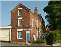
Looking up White Hart Yard
All but the nearest building, actually addressed in Lead Hill – are Listed Grade II, but with trees still in leaf impossible to do justice to in a photograph.
Image: © Alan Murray-Rust
Taken: 4 Oct 2015
0.01 miles
2
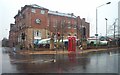
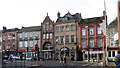
Worksop Market
The entrance to Worksop Market. Also showing the council offices.
Image: © Ann B
Taken: 14 Jan 2006
0.02 miles
3
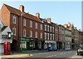
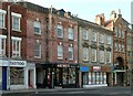
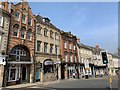
Houses on Bridge Street facing the Market Place
These are all Listed Grade II. The two nearer buildings are: 132/132a Bridge Street, mid 18th century house of 5 bays with later shopfronts from either side of 1900; 130-126 Bridge Street, 4 bay house dated 1761, converted to retail use with modern shop front.
Image: © Alan Murray-Rust
Taken: 4 Oct 2015
0.04 miles
4
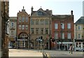
Buildings on Bridge Street at Market Place
Compared with buildings down Bridge Street to the right, this group represents redevelopment from around 1900. The central building was originally a bank. All three are Listed Grade II, although that on the right only for group value.
Image: © Alan Murray-Rust
Taken: 4 Oct 2015
0.04 miles
5
Buildings on Bridge Street facing the Market Place
The nearer building is a mid 18th century house dated 1760 later converted for retail use with 20th century shop front. The pillars flanking this may be original. Note the ghost writing between the first floor windows. Listed Grade II. The right hand building (122/120) is mid 19th century, built as commercial property. Listed Grade II for group value.
Image: © Alan Murray-Rust
Taken: 4 Oct 2015
0.04 miles
6
Worksop - shops on west side of Market Place
Image: © Dave Bevis
Taken: 4 Jan 2013
0.04 miles
7
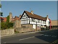
Ship Inn, south range
Although parts of the Listed Grade II* Ship Inn are timber framed dating back to the late 16th Century, this wing was not added until 1938.
Image: © Alan Murray-Rust
Taken: 4 Oct 2015
0.04 miles
8
Potter Street at Park Street
Town Hall on the left
Image: © John Firth
Taken: 19 Jun 2012
0.04 miles
9
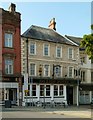
The Lion Hotel
This 18th century 4 bay building has retained its traditional image better than most others of the same period in Bridge Street. Uniquely it retains the 19th century cast iron cresting to the fascia board. In most cases the remainder were removed during WW2 for scrap. Listed Grade II.
Image: © Alan Murray-Rust
Taken: 4 Oct 2015
0.04 miles
10
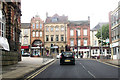
Bridge Street, Worksop
Historic buildings at the top of Bridge Street, Worksop.
Image: © Andrew Abbott
Taken: 30 Mar 2019
0.04 miles