IMAGES TAKEN NEAR TO
William Straw Gardens, WORKSOP, S80 1HJ
Introduction
This page details the photographs taken nearby to William Straw Gardens, S80 1HJ by members of the Geograph project.
The Geograph project started in 2005 with the aim of publishing, organising and preserving representative images for every square kilometre of Great Britain, Ireland and the Isle of Man.

There are currently over 7.5m images from over14,400 individuals and you can help contribute to the project by visiting https://www.geograph.org.uk
Image Map
Images are licensed for reuse under creativecommons.org/licenses/by-sa/2.0
Notes
- Clicking on the map will re-center to the selected point.
- The higher the marker number, the further away the image location is from the centre of the postcode.
Image Listing (83 Images Found)
Images are licensed for reuse under creativecommons.org/licenses/by-sa/2.0
Image
Details
Distance
1
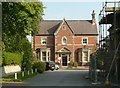
Newcastle House
One of a group of villas built by the Duke of Newcastle around 1850 after he purchased Worksop Manor. This was originally the estate office. They are thought to be by the Nottingham architect T C Hine who was the Duke's official surveyor from 1854.
Image: © Alan Murray-Rust
Taken: 4 Oct 2015
0.09 miles
2
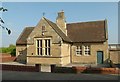
St Mary's Church School
Mid 19th century school for the Roman Catholic community, now church hall. Listed Grade II for group value.
Image: © Alan Murray-Rust
Taken: 4 Oct 2015
0.10 miles
3
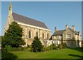
Church of St Mary, Park Street
Roman Catholic Church, built in 1838 for the Duke of Norfolk, an adherent to the Catholic faith. Designed by M E Hadfield in Perpendicular revival style, Listed Grade II. The attached presbytery does not form part of the listing.
Image: © Alan Murray-Rust
Taken: 4 Oct 2015
0.11 miles
4
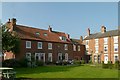
Park Place
The range to the left comprising 3 houses dates from the late 18th century and is Listed Grade II.
Image: © Alan Murray-Rust
Taken: 4 Oct 2015
0.12 miles
5
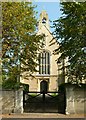
Church of St Mary, Park Street
Roman Catholic Church, built in 1838 for the Duke of Norfolk, an adherent to the Catholic faith. Listed Grade II. This is the entrance off Park Street. There is a bench mark http://www.geograph.org.uk/photo/4691380 on the wall to the left of the gateway.
Image: © Alan Murray-Rust
Taken: 4 Oct 2015
0.12 miles
7
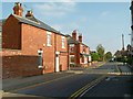
Newgate Street, looking east
There is a bench mark http://www.geograph.org.uk/photo/4691527 on the near corner of the house on the left.
Image: © Alan Murray-Rust
Taken: 4 Oct 2015
0.13 miles
8
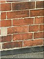
Bench mark, Newgate Street
See http://www.geograph.org.uk/photo/4691529 for location.
Image: © Alan Murray-Rust
Taken: 4 Oct 2015
0.13 miles
9
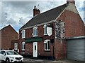
House that was The Reindeer
Looks like it was closed in or soon after 2009 https://maps.app.goo.gl/Tf6KG4VbGuXgLAEP9
Image: © David Lally
Taken: 20 Jul 2024
0.13 miles
10
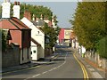
Park Street
This was traditionally the main entry to the town from the south. The new Savoy Cinema forms a significant visual stop to the vista.
Image: © Alan Murray-Rust
Taken: 4 Oct 2015
0.13 miles