IMAGES TAKEN NEAR TO
Mayfair Row, WORKSOP, S80 1FA
Introduction
This page details the photographs taken nearby to Mayfair Row, S80 1FA by members of the Geograph project.
The Geograph project started in 2005 with the aim of publishing, organising and preserving representative images for every square kilometre of Great Britain, Ireland and the Isle of Man.

There are currently over 7.5m images from over14,400 individuals and you can help contribute to the project by visiting https://www.geograph.org.uk
Image Map
Images are licensed for reuse under creativecommons.org/licenses/by-sa/2.0
Notes
- Clicking on the map will re-center to the selected point.
- The higher the marker number, the further away the image location is from the centre of the postcode.
Image Listing (134 Images Found)
Images are licensed for reuse under creativecommons.org/licenses/by-sa/2.0
Image
Details
Distance
1
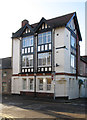
Worksop - former Norfolk Arms
On Norfolk Street.
Image: © Dave Bevis
Taken: 4 Jan 2013
0.06 miles
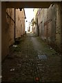
3
Looking up White Hart Yard
All but the nearest building, actually addressed in Lead Hill – are Listed Grade II, but with trees still in leaf impossible to do justice to in a photograph.
Image: © Alan Murray-Rust
Taken: 4 Oct 2015
0.10 miles
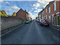
4

Worksop - Norfolk Street junction with Newcastle Avenue
Image: © Alan Heardman
Taken: 11 Nov 2008
0.11 miles
5
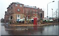
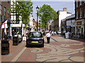
Worksop Market
The entrance to Worksop Market. Also showing the council offices.
Image: © Ann B
Taken: 14 Jan 2006
0.12 miles
7
Plants Yard
Probably the most authentic remaining 'yard' or through alley leading off Bridge Street. On this side of the street, development from medieval times was in the form of long narrow burgage plots, and these yards were typical of the need to provide access to buildings at the rear, often with original main building in a L shape, the foot of the L spanning the yard, as here.. To the right can be seen the bricked up openings to what would originally have been tenement dwellings.
Image: © Alan Murray-Rust
Taken: 4 Oct 2015
0.13 miles
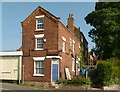
8
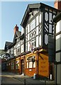
Swan Inn, Castle Street
Built/rebuilt 1926 with a rich amber-coloured faience frontage, a colour favoured by the owning brewery, Tomlinsons of Sheffield (cf: http://www.geograph.org.uk/photo/2030820 )
Image: © Alan Murray-Rust
Taken: 4 Oct 2015
0.13 miles
9
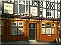
Swan Inn, Castle Street
Built/rebuilt 1926 with a rich amber-coloured faience frontage, a colour favoured by the owning brewery, Tomlinsons of Sheffield (cf: http://www.geograph.org.uk/photo/2030820 )
Image: © Alan Murray-Rust
Taken: 4 Oct 2015
0.13 miles
10
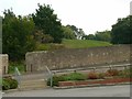
Nondescript grassy mound and enclosing wall
The mound is in fact the motte of the medieval castle of around 1100, and the site is a Scheduled Monument.
Image: © Alan Murray-Rust
Taken: 4 Oct 2015
0.13 miles