IMAGES TAKEN NEAR TO
Sparken Hill, WORKSOP, S80 1AW
Introduction
This page details the photographs taken nearby to Sparken Hill, S80 1AW by members of the Geograph project.
The Geograph project started in 2005 with the aim of publishing, organising and preserving representative images for every square kilometre of Great Britain, Ireland and the Isle of Man.

There are currently over 7.5m images from over14,400 individuals and you can help contribute to the project by visiting https://www.geograph.org.uk
Image Map (Loading...)


Getting Data...Please wait
Leaflet Map data © OpenStreetMap
Images are licensed for reuse under creativecommons.org/licenses/by-sa/2.0
Notes
- Clicking on the map will re-center to the selected point.
- The higher the marker number, the further away the image location is from the centre of the postcode.
Image Listing (17 Images Found)
Images are licensed for reuse under creativecommons.org/licenses/by-sa/2.0
Image
Details
Distance
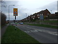
1
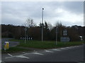
A57 approaching roundabout
Heading east south of Worksop.
Image: © JThomas
Taken: 17 Mar 2014
0.08 miles
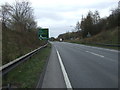
2
A57 Worksop By-pass
Looking down from Sparken Hill overbridge. The by-pass is only single carriageway at this point.
Image: © Alan Murray-Rust
Taken: 4 Oct 2015
0.09 miles
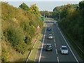
3
Worksop bypass A57
Looking west along the A57
Image: © roger geach
Taken: 6 Nov 2011
0.10 miles
4
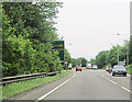
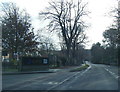
A57 east approaching Netherton Road
Signs for Netherton Road roundabout partially hidden in the trees
Image: © John Firth
Taken: 12 Jun 2012
0.12 miles
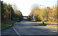
5
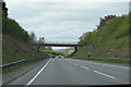
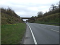
Bridge over the A57
Sparken Hill road crosses.
Image: © Julian P Guffogg
Taken: 5 May 2013
0.12 miles