IMAGES TAKEN NEAR TO
Moorland Avenue, BARNSLEY, S75 6NP
Introduction
This page details the photographs taken nearby to Moorland Avenue, S75 6NP by members of the Geograph project.
The Geograph project started in 2005 with the aim of publishing, organising and preserving representative images for every square kilometre of Great Britain, Ireland and the Isle of Man.

There are currently over 7.5m images from over14,400 individuals and you can help contribute to the project by visiting https://www.geograph.org.uk
Image Map
Images are licensed for reuse under creativecommons.org/licenses/by-sa/2.0
Notes
- Clicking on the map will re-center to the selected point.
- The higher the marker number, the further away the image location is from the centre of the postcode.
Image Listing (3 Images Found)
Images are licensed for reuse under creativecommons.org/licenses/by-sa/2.0
Image
Details
Distance
1
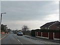
New Road
Well it must have been once!
Image: © Christine Johnstone
Taken: 9 Feb 2011
0.22 miles
2
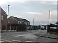
Melford Close, off New Road
With extensive views to the south.
Image: © Christine Johnstone
Taken: 9 Feb 2011
0.24 miles
3
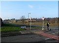
Road Junction near Warren Farm
This is actually a crossroads where Warren Lane continues towards the farm out of shot on the right.
Image: © Jonathan Clitheroe
Taken: 13 Feb 2017
0.25 miles