IMAGES TAKEN NEAR TO
New Street, BARNSLEY, S75 6EN
Introduction
This page details the photographs taken nearby to New Street, S75 6EN by members of the Geograph project.
The Geograph project started in 2005 with the aim of publishing, organising and preserving representative images for every square kilometre of Great Britain, Ireland and the Isle of Man.

There are currently over 7.5m images from over14,400 individuals and you can help contribute to the project by visiting https://www.geograph.org.uk
Image Map
Images are licensed for reuse under creativecommons.org/licenses/by-sa/2.0
Notes
- Clicking on the map will re-center to the selected point.
- The higher the marker number, the further away the image location is from the centre of the postcode.
Image Listing (13 Images Found)
Images are licensed for reuse under creativecommons.org/licenses/by-sa/2.0
Image
Details
Distance
1
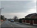
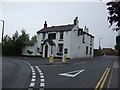
New Road
Well it must have been once!
Image: © Christine Johnstone
Taken: 9 Feb 2011
0.04 miles
2
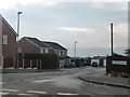
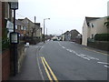
Melford Close, off New Road
With extensive views to the south.
Image: © Christine Johnstone
Taken: 9 Feb 2011
0.07 miles
4
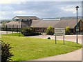
Wellgate Primary School
Primary school at Staincross and Mapplewell.
Image: © Roger May
Taken: 28 May 2006
0.12 miles
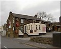
5
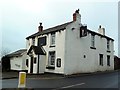
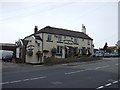
The King's Head
Looking neglected and quite possibly now closed.
Image: © Graham Hogg
Taken: 11 Jan 2012
0.16 miles
10
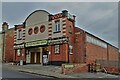
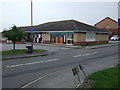
"The Old Picture House", Greenside, Staincross
Once a cinema but now premises for commercial sales including vending machines
Image: © Neil Theasby
Taken: 21 Jan 2022
0.24 miles