IMAGES TAKEN NEAR TO
Hope Street, BARNSLEY, S75 6DA
Introduction
This page details the photographs taken nearby to Hope Street, S75 6DA by members of the Geograph project.
The Geograph project started in 2005 with the aim of publishing, organising and preserving representative images for every square kilometre of Great Britain, Ireland and the Isle of Man.

There are currently over 7.5m images from over14,400 individuals and you can help contribute to the project by visiting https://www.geograph.org.uk
Image Map
Images are licensed for reuse under creativecommons.org/licenses/by-sa/2.0
Notes
- Clicking on the map will re-center to the selected point.
- The higher the marker number, the further away the image location is from the centre of the postcode.
Image Listing (16 Images Found)
Images are licensed for reuse under creativecommons.org/licenses/by-sa/2.0
Image
Details
Distance
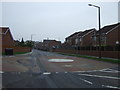
4
Houses under construction, Blacker Road
Image: © Alex McGregor
Taken: 26 Jun 2012
0.10 miles

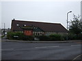
6
Dyson Insulations Ltd
Carrying out work in Barnsley.
Image: © Burgess Von Thunen
Taken: 27 Feb 2013
0.11 miles
8

Rowan Berries
Also called Mountain Ash.
Image: © John Fielding
Taken: 11 Aug 2009
0.18 miles
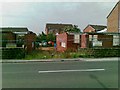
10
Mapplewell Police Station
Situated on Blacker Road. A garden War Memorial is partially visible to the left of the station.
Image: © Jonathan Clitheroe
Taken: 13 Feb 2017
0.21 miles