IMAGES TAKEN NEAR TO
Lansdowne Crescent, BARNSLEY, S75 5PP
Introduction
This page details the photographs taken nearby to Lansdowne Crescent, S75 5PP by members of the Geograph project.
The Geograph project started in 2005 with the aim of publishing, organising and preserving representative images for every square kilometre of Great Britain, Ireland and the Isle of Man.

There are currently over 7.5m images from over14,400 individuals and you can help contribute to the project by visiting https://www.geograph.org.uk
Image Map
Images are licensed for reuse under creativecommons.org/licenses/by-sa/2.0
Notes
- Clicking on the map will re-center to the selected point.
- The higher the marker number, the further away the image location is from the centre of the postcode.
Image Listing (41 Images Found)
Images are licensed for reuse under creativecommons.org/licenses/by-sa/2.0
Image
Details
Distance
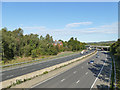
1
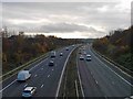
Looking south on the M1 motorway at Kexbrough
From Churchfield Lane.
Image: © Steve Fareham
Taken: 15 Nov 2008
0.06 miles
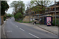
3
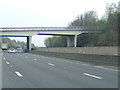
M1 passes under Churchfield Lane overbridge
Image: © Colin Pyle
Taken: 7 Apr 2019
0.10 miles
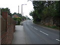
8
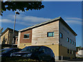
The Darton Centre
A medical centre with access off Huddersfield Road, though this is the side view from Churchfield Lane.
Image: © Stephen Craven
Taken: 17 Oct 2019
0.16 miles
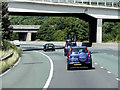
9
The M1 near Darton, looking north
The photo is taken from Churchfield Lane bridge Image and the bridge in this view is the A637.
Image: © Stephen Craven
Taken: 17 Oct 2019
0.17 miles
10
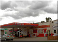
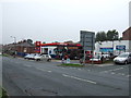
What a combination.
Petrol and booze.
Image: © Steve Fareham
Taken: 3 Sep 2007
0.17 miles