IMAGES TAKEN NEAR TO
Hedge Lane, BARNSLEY, S75 5PN
Introduction
This page details the photographs taken nearby to Hedge Lane, S75 5PN by members of the Geograph project.
The Geograph project started in 2005 with the aim of publishing, organising and preserving representative images for every square kilometre of Great Britain, Ireland and the Isle of Man.

There are currently over 7.5m images from over14,400 individuals and you can help contribute to the project by visiting https://www.geograph.org.uk
Image Map
Images are licensed for reuse under creativecommons.org/licenses/by-sa/2.0
Notes
- Clicking on the map will re-center to the selected point.
- The higher the marker number, the further away the image location is from the centre of the postcode.
Image Listing (19 Images Found)
Images are licensed for reuse under creativecommons.org/licenses/by-sa/2.0
Image
Details
Distance
1
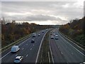
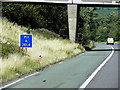
Looking south on the M1 motorway at Kexbrough
From Churchfield Lane.
Image: © Steve Fareham
Taken: 15 Nov 2008
0.12 miles
2
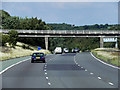
Northbound M1, Bence Lane Bridge near Kexbrough
Image: © David Dixon
Taken: 8 Aug 2015
0.17 miles
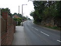
4
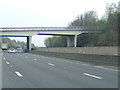
M1 passes under Churchfield Lane overbridge
Image: © Colin Pyle
Taken: 7 Apr 2019
0.17 miles
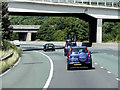
5
Driver Location Sign at Bence Lane Bridge
Driver location signs are now widely used across the motorway and A–road network. First introduced in 2003, they complement distance marker posts. Both types of marker post display the distances in kilometres from a nominal start point but driver location signs are designed to be read by motorists or their passengers when, for instance, they need to pass details to the emergency services. They give the same location information as distance marker posts, but more visibly on larger signs. They are normally spaced at 500-metre intervals along the nearside verge but if obstacles (eg sliproads or bridges) prevent signs from being erected at these locations, then the interval is reduced to either 400 or 300 metres.
Driver location signs display three pieces of information:
• The road identifier (eg M1 in this example)
• The carriageway identifier – The letter on the second line of the signs, usually “A” or “B”, tells the emergency services or the Highways Agency in which direction you are travelling. The letter “A” ("Away from London") normally denotes carriageways leaving London and "B" ("Back to London") is used for carriageways going to London. In this example, "A" tells us that we are on the northbound carriageway, travelling away from London.
• The location (which is identical to the location given on marker posts). Distances are accurate to within 20 metres and are generally quoted from the beginning of the motorway. In this example, we are 281.4 km from the start of the motorway.
http://www.dft.gov.uk/ha/standards/ians/pdfs/ian93r1.pdf DFT Interim Advice Note (December 2010)
http://www.theaa.com/motoring_advice/breakdown_advice/driver-location-signs.html The AA
http://www.sabre-roads.org.uk/wiki/index.php?title=Driver_Location_Signs SABRE
Image: © David Dixon
Taken: 8 Aug 2015
0.17 miles
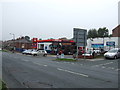
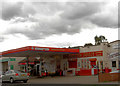
10
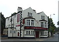
The Rose and Crown, Barnsley Road, Darton
See also Image
Image: © Stephen Craven
Taken: 17 Oct 2019
0.23 miles