IMAGES TAKEN NEAR TO
Bretton Close, BARNSLEY, S75 5LF
Introduction
This page details the photographs taken nearby to Bretton Close, S75 5LF by members of the Geograph project.
The Geograph project started in 2005 with the aim of publishing, organising and preserving representative images for every square kilometre of Great Britain, Ireland and the Isle of Man.

There are currently over 7.5m images from over14,400 individuals and you can help contribute to the project by visiting https://www.geograph.org.uk
Image Map
Images are licensed for reuse under creativecommons.org/licenses/by-sa/2.0
Notes
- Clicking on the map will re-center to the selected point.
- The higher the marker number, the further away the image location is from the centre of the postcode.
Image Listing (15 Images Found)
Images are licensed for reuse under creativecommons.org/licenses/by-sa/2.0
Image
Details
Distance

3
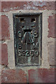
Flush Bracket Bench Mark, Darton
Bench Mark Database: http://www.bench-marks.org.uk/bm21472
Image: © Mark Anderson
Taken: 15 Apr 2011
0.19 miles
4
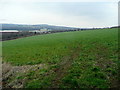
View over the Dearne Valley
Looking east from Ballfield Lane, north of Kexbrough.
Image: © Jonathan Billinger
Taken: 19 Feb 2009
0.20 miles
5
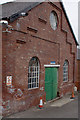
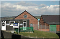
The Wheelhouse, Junction 38 Business Park
There is a flush bracket benchmark on the corner to the left. A closer view can be seen here: Image Interestingly, the bench mark surveyor's description describes this building as glass works but the security guard who accompanied me explained that the building was the wheel house for a mine.
Image: © Mark Anderson
Taken: 15 Apr 2011
0.20 miles
6
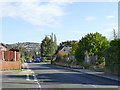
Churchfield Lane, Kexborough
The photo is taken from the junction with Strafford Street, looking East. A local bus is approaching.
Image: © Stephen Craven
Taken: 17 Oct 2019
0.20 miles
7
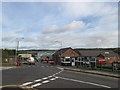
Junction 38 Business Park
Older buildings, with tasteful details in their brickwork, have been 'integrated' alongside less subtle modern industrial estate architecture.
Image: © Chris Yeates
Taken: 3 Mar 2006
0.20 miles
9
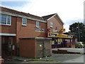
Convenience store on Ballfield Lane, Kexbrough
Image: © JThomas
Taken: 3 Oct 2014
0.22 miles
10
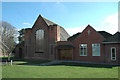
Kexbrough Methodist Church
The date on the cross on the newer part of the building to the right is dated 2000. The protective covering to the large window is, sadly, a sign of the times.
Image: © Chris Yeates
Taken: 3 Mar 2006
0.23 miles