IMAGES TAKEN NEAR TO
Church Street, BARNSLEY, S75 5HQ
Introduction
This page details the photographs taken nearby to Church Street, S75 5HQ by members of the Geograph project.
The Geograph project started in 2005 with the aim of publishing, organising and preserving representative images for every square kilometre of Great Britain, Ireland and the Isle of Man.

There are currently over 7.5m images from over14,400 individuals and you can help contribute to the project by visiting https://www.geograph.org.uk
Image Map
Images are licensed for reuse under creativecommons.org/licenses/by-sa/2.0
Notes
- Clicking on the map will re-center to the selected point.
- The higher the marker number, the further away the image location is from the centre of the postcode.
Image Listing (95 Images Found)
Images are licensed for reuse under creativecommons.org/licenses/by-sa/2.0
Image
Details
Distance
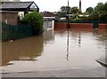
1
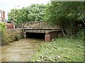
Church Street Bridge over the River Dearne
This area had been flooded again 12 hours earlier, the vegetation is flat in the lower right hand corner, caused by the flood.
Image: © John Fielding
Taken: 26 Jun 2007
0.01 miles
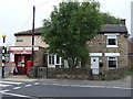
2
Former Darton Infants School
Now used as a Scout hut.
Image: © Stephen Craven
Taken: 17 Oct 2019
0.01 miles
3
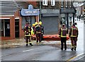
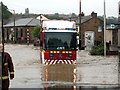
Church Street Darton Flooded
Energency services to the rescue
Image: © John Fielding
Taken: 15 Jun 2007
0.01 miles
4
Church Street Darton Flooded
Emergency Services get through.
Image: © John Fielding
Taken: 15 Jun 2007
0.02 miles
6
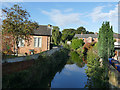
The River Dearne in Darton
Viewed from Church Street bridge.
Image: © Stephen Craven
Taken: 17 Oct 2019
0.02 miles
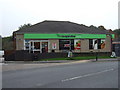
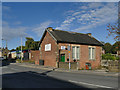
8
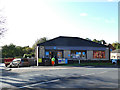
Darton Co-Operative store
It's had a makeover since 2013 Image
Image: © Stephen Craven
Taken: 17 Oct 2019
0.02 miles
9
Darton Fish Shop Flooded.
After the River Dearne overflows.
Image: © John Fielding
Taken: 15 Jun 2007
0.02 miles