IMAGES TAKEN NEAR TO
Maydal Drive, BARNSLEY, S75 5GN
Introduction
This page details the photographs taken nearby to Maydal Drive, S75 5GN by members of the Geograph project.
The Geograph project started in 2005 with the aim of publishing, organising and preserving representative images for every square kilometre of Great Britain, Ireland and the Isle of Man.

There are currently over 7.5m images from over14,400 individuals and you can help contribute to the project by visiting https://www.geograph.org.uk
Image Map (Loading...)


Getting Data...Please wait
Leaflet Map data © OpenStreetMap
Images are licensed for reuse under creativecommons.org/licenses/by-sa/2.0
Notes
- Clicking on the map will re-center to the selected point.
- The higher the marker number, the further away the image location is from the centre of the postcode.
Image Listing (16 Images Found)
Images are licensed for reuse under creativecommons.org/licenses/by-sa/2.0
Image
Details
Distance
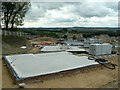
1
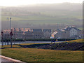
New housing development on the old Woolley Colliery site
This site overlooks the M1 to the west. To the NW is the Yorkshire Sculpture Park at Bretton.
Image: © Wendy North
Taken: 30 Jan 2006
0.01 miles
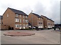
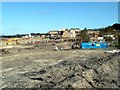
2
Apartments and housing on the site of the former Woolley Colliery
Image: © Steve Fareham
Taken: 31 Jan 2008
0.06 miles
3
Gresford Close at the junction with The Grange
Formerly Woolley Colliery site.
Image: © John Fielding
Taken: 25 Feb 2008
0.06 miles
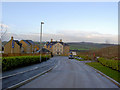
4

Approaching Windhill Rise
On the Woolley Grange estate
Image: © Neil Theasby
Taken: 21 Jan 2022
0.07 miles
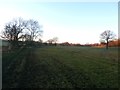
5
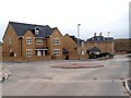
The Grange at the roundabout
A new street on the old Woolley Colliery site, part of the old spoil heaps can be seen as a bank at the middle right hand side of pic.
Image: © John Fielding
Taken: 25 Feb 2008
0.07 miles
6
Under construction
More houses being built on the Old Woolley Colliery site, with potential for very large cellars. Pic taken from the west side of the colliery managers house on the edge of Windhill Wood.
Image: © John Fielding
Taken: 12 Aug 2010
0.16 miles
7
New for Old
New houses on old Woolley Colliery Site
Image: © John Fielding
Taken: 18 Apr 2007
0.17 miles
8
River Dearne Flood Plain
Pictured from the Dearne Way footpath. The river itself follows the field boundary on the left and also separates South and West Yorkshire.
Image: © Jonathan Clitheroe
Taken: 25 Jan 2017
0.18 miles
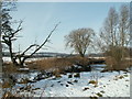
9
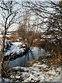
The River Dearne
Pic taken from the Dearne Way to Haigh.
Image: © John Fielding
Taken: 9 Feb 2009
0.19 miles
10
The River Dearne From The Dearne Way
The buildings in the top left hand quarter of pic are Riverside Farm at the side of the M1.
Image: © John Fielding
Taken: 9 Feb 2009
0.19 miles