IMAGES TAKEN NEAR TO
Bloomfield Rise, BARNSLEY, S75 5AB
Introduction
This page details the photographs taken nearby to Bloomfield Rise, S75 5AB by members of the Geograph project.
The Geograph project started in 2005 with the aim of publishing, organising and preserving representative images for every square kilometre of Great Britain, Ireland and the Isle of Man.

There are currently over 7.5m images from over14,400 individuals and you can help contribute to the project by visiting https://www.geograph.org.uk
Image Map
Images are licensed for reuse under creativecommons.org/licenses/by-sa/2.0
Notes
- Clicking on the map will re-center to the selected point.
- The higher the marker number, the further away the image location is from the centre of the postcode.
Image Listing (7 Images Found)
Images are licensed for reuse under creativecommons.org/licenses/by-sa/2.0
Image
Details
Distance
1
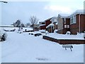
Not so sunny Sunningdale Avenue
Pic taken from the junction with St Andrews Drive.
Image: © John Fielding
Taken: 1 Dec 2010
0.14 miles
2

Foxglove (Digitalis purpurea)
Pic taken on Bloomhouse Lane.
Image: © John Fielding
Taken: 11 Jun 2010
0.16 miles
3
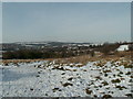
The End of Howden Close looking to Darton
Image: © John Fielding
Taken: 9 Feb 2009
0.19 miles
4
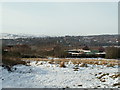
Darton from land at Bloomhouse Lane
Darton Church Tower can be seen centre of pic.
Image: © John Fielding
Taken: 9 Feb 2009
0.21 miles
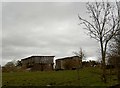
6
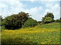
A splash of yellow
A field on the northern edge of Bloomhouse Lane.
Image: © John Fielding
Taken: 11 Jun 2010
0.24 miles
7
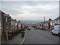
Dropping down the hillside
Princess Street connects New Road [top] to Kingsway [bottom].
Image: © Christine Johnstone
Taken: 9 Feb 2011
0.24 miles