IMAGES TAKEN NEAR TO
Haigh Lane, BARNSLEY, S75 4DB
Introduction
This page details the photographs taken nearby to Haigh Lane, S75 4DB by members of the Geograph project.
The Geograph project started in 2005 with the aim of publishing, organising and preserving representative images for every square kilometre of Great Britain, Ireland and the Isle of Man.

There are currently over 7.5m images from over14,400 individuals and you can help contribute to the project by visiting https://www.geograph.org.uk
Image Map
Images are licensed for reuse under creativecommons.org/licenses/by-sa/2.0
Notes
- Clicking on the map will re-center to the selected point.
- The higher the marker number, the further away the image location is from the centre of the postcode.
Image Listing (18 Images Found)
Images are licensed for reuse under creativecommons.org/licenses/by-sa/2.0
Image
Details
Distance
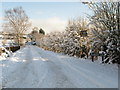
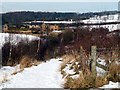
1
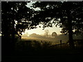
Haigh Lane to Near Moor Farm
On a frosty Sunday morning with the sun rising.
Image: © John Fielding
Taken: 21 Oct 2007
0.04 miles
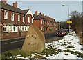
3

Haigh Millennium Stone
Close to Haigh Free & Independent Pentecostal Church.
Image: © David Rogers
Taken: 7 Jan 2010
0.06 miles
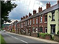
6
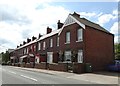
Former coal miners' cottages on Haigh Lane
Image: © Neil Theasby
Taken: 21 May 2014
0.09 miles
7
Moorhouse Lane, Haigh
Part of the Barnsley Boundary Walk.
Image: © David Rogers
Taken: 7 Jan 2010
0.09 miles
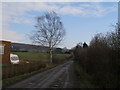
8
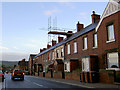
Haigh Lane
Heading towards the M1 motorway junction.
Image: © Steve Fareham
Taken: 31 Jan 2008
0.09 miles
9
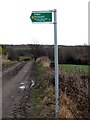
Footpath sign to Woolley Edge Lane & Haigh Hill
On Moorhouse Lane at the entrance to Near Moor Farm. Note Woolley is spelt Wooley on the sign which is wrong.
Image: © John Fielding
Taken: 1 Feb 2009
0.10 miles
10
Near Moor Farm
Pic taken from the new path to Woolley Estate.
Image: © John Fielding
Taken: 9 Feb 2009
0.12 miles