IMAGES TAKEN NEAR TO
West Road, BARNSLEY, S75 2DR
Introduction
This page details the photographs taken nearby to West Road, S75 2DR by members of the Geograph project.
The Geograph project started in 2005 with the aim of publishing, organising and preserving representative images for every square kilometre of Great Britain, Ireland and the Isle of Man.

There are currently over 7.5m images from over14,400 individuals and you can help contribute to the project by visiting https://www.geograph.org.uk
Image Map
Images are licensed for reuse under creativecommons.org/licenses/by-sa/2.0
Notes
- Clicking on the map will re-center to the selected point.
- The higher the marker number, the further away the image location is from the centre of the postcode.
Image Listing (12 Images Found)
Images are licensed for reuse under creativecommons.org/licenses/by-sa/2.0
Image
Details
Distance
1
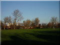
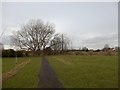
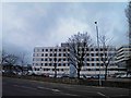
Playing Fields
Looking across Pogmoor Playing Fields to Barnsley Hospital.
Image: © John Douglas
Taken: 26 Nov 2006
0.10 miles
2
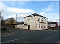
The Tom Treddlehoyle Public House in Barnsley
Pub located on the corner of Pogmoor Road and Intake Lane. The unusual name relates to a certain Charles Rogers who employed this pseudonym to write locally-themed almanacs which were popular during the mid 19th century.
Image: © Jonathan Clitheroe
Taken: 13 Mar 2017
0.12 miles
3
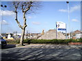
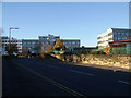
On Dodworth Road. Barnsley
Old Polar Garage. about to become 52 new Homes By Bellway.
Image: © Barry Potter
Taken: 1 Mar 2011
0.16 miles
5
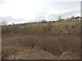
Penny Pie Park
Looking towards the railway line.
Image: © Darren Haddock
Taken: 14 Feb 2018
0.19 miles
6
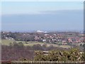
Barnsley Hospital from Green Moor, near Wortley
The Hospital is the multi-storey building on the horizon ... the houses in the mid ground are in Thurgoland ... Image
Image: © Terry Robinson
Taken: 8 Mar 2010
0.21 miles
7
Summer Lane
Barnsley Hospital at the top of summer lane.
Image: © John Douglas
Taken: 26 Nov 2004
0.21 miles
9
Barnsley District General Hospital from Pogmoor Road
Image: © Steve Fareham
Taken: 6 Jan 2013
0.24 miles
10
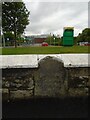
Old milestone
This 'listed' milestone from the 27 mile long Doncaster to Saltersbrook turnpike of 1740-1871 is on Dodworth Road, Barnsley (A628). It was, until 2010, in the low front wall of a petrol station. When this closed and was demolished to make the entrance for the new Horizon Academy in 2012 it was preserved. The eroded legend reads Barnsley/1 Mile/Manchester/(3)5 Miles. Two milestones are still in situ between Doncaster and Barnsley with 7 more to the boundary at Saltersbrook Bridge. Grade II listed 1191519.
Milestone Society National ID:YS_BNMC01
Image: © Chris Minto
Taken: 6 Jun 2022
0.24 miles