IMAGES TAKEN NEAR TO
Selbourne Close, BARNSLEY, S75 1NA
Introduction
This page details the photographs taken nearby to Selbourne Close, S75 1NA by members of the Geograph project.
The Geograph project started in 2005 with the aim of publishing, organising and preserving representative images for every square kilometre of Great Britain, Ireland and the Isle of Man.

There are currently over 7.5m images from over14,400 individuals and you can help contribute to the project by visiting https://www.geograph.org.uk
Image Map
Images are licensed for reuse under creativecommons.org/licenses/by-sa/2.0
Notes
- Clicking on the map will re-center to the selected point.
- The higher the marker number, the further away the image location is from the centre of the postcode.
Image Listing (19 Images Found)
Images are licensed for reuse under creativecommons.org/licenses/by-sa/2.0
Image
Details
Distance

5
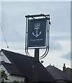
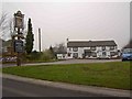
The Crown and Anchor
Closed for the second COVID-19 lockdown.
Image: © David Lally
Taken: 12 Nov 2020
0.15 miles
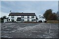
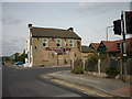
6
The Crown and Anchor (Shukria Indian restaurant)
At Barugh pronounced 'Bark'.
Image: © Steve Fareham
Taken: 31 Dec 2008
0.17 miles
8
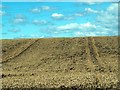
Barugh Hill
From the A625 at Barugh Green. The lines across the sky are from the pylons which are close by.
Image: © John Fielding
Taken: 8 Aug 2007
0.17 miles
10
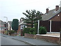
Monkey puzzle tree (Araucaria araucana)
In a front garden, Langdale Drive, Barugh
Image: © JThomas
Taken: 25 Sep 2013
0.18 miles