IMAGES TAKEN NEAR TO
Raley Drive, BARNSLEY, S75 1FL
Introduction
This page details the photographs taken nearby to Raley Drive, S75 1FL by members of the Geograph project.
The Geograph project started in 2005 with the aim of publishing, organising and preserving representative images for every square kilometre of Great Britain, Ireland and the Isle of Man.

There are currently over 7.5m images from over14,400 individuals and you can help contribute to the project by visiting https://www.geograph.org.uk
Image Map
Images are licensed for reuse under creativecommons.org/licenses/by-sa/2.0
Notes
- Clicking on the map will re-center to the selected point.
- The higher the marker number, the further away the image location is from the centre of the postcode.
Image Listing (6 Images Found)
Images are licensed for reuse under creativecommons.org/licenses/by-sa/2.0
Image
Details
Distance

4
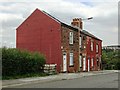
Terraced houses on Smithies Lane, Barnsley
Image: © Neil Theasby
Taken: 2 Sep 2014
0.20 miles
6
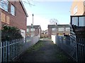
Footpath to Hartington Drive, Honeywell
Heading west from open space that was once the route of the Barnsley Canal.
Image: © Christine Johnstone
Taken: 31 Dec 2017
0.24 miles