IMAGES TAKEN NEAR TO
Milton Croft, BARNSLEY, S74 9NS
Introduction
This page details the photographs taken nearby to Milton Croft, S74 9NS by members of the Geograph project.
The Geograph project started in 2005 with the aim of publishing, organising and preserving representative images for every square kilometre of Great Britain, Ireland and the Isle of Man.

There are currently over 7.5m images from over14,400 individuals and you can help contribute to the project by visiting https://www.geograph.org.uk
Image Map
Images are licensed for reuse under creativecommons.org/licenses/by-sa/2.0
Notes
- Clicking on the map will re-center to the selected point.
- The higher the marker number, the further away the image location is from the centre of the postcode.
Image Listing (6 Images Found)
Images are licensed for reuse under creativecommons.org/licenses/by-sa/2.0
Image
Details
Distance
1

Footpath to the Jump Valley from Greenside Lane
Image: © Jonathan Clitheroe
Taken: 17 Feb 2017
0.10 miles
2

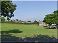
Site of Jump Pit and former tramroad
The pit was in the area to the right. The mown track represents roughly the alignment of the incline of the tramroad down to the Dearne and Dove Canal.
Image: © Alan Murray-Rust
Taken: 8 Jul 2013
0.15 miles
3
Jump Recreation Ground
This lower section appears as a reservoir on older OS maps.
Image: © Alan Murray-Rust
Taken: 8 Jul 2013
0.22 miles
4

Roebuck Hill towards Jump
The left turn at the bottom leads into Cemetery Road.
Image: © Julian P Guffogg
Taken: 21 May 2016
0.22 miles
5
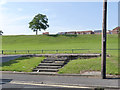
Jump Library steps
The library still shows on OS maps, but clearly the building has been demolished for some time.
Image: © Alan Murray-Rust
Taken: 8 Jul 2013
0.25 miles
6

Is this bus going to Jump?
Apologies an old local joke!
Image: © Steve Fareham
Taken: 9 Sep 2007
0.25 miles