IMAGES TAKEN NEAR TO
Coronation Road, BARNSLEY, S74 9HP
Introduction
This page details the photographs taken nearby to Coronation Road, S74 9HP by members of the Geograph project.
The Geograph project started in 2005 with the aim of publishing, organising and preserving representative images for every square kilometre of Great Britain, Ireland and the Isle of Man.

There are currently over 7.5m images from over14,400 individuals and you can help contribute to the project by visiting https://www.geograph.org.uk
Image Map
Images are licensed for reuse under creativecommons.org/licenses/by-sa/2.0
Notes
- Clicking on the map will re-center to the selected point.
- The higher the marker number, the further away the image location is from the centre of the postcode.
Image Listing (10 Images Found)
Images are licensed for reuse under creativecommons.org/licenses/by-sa/2.0
Image
Details
Distance
1
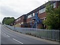
Metalliform Holdings
This is where your chair you swung on at school probably came from. Manufacturers of office and educational furniture.
Image: © Richard Webb
Taken: 30 May 2023
0.09 miles
3
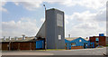
Who stole the bridge?
This was a stair tower to a bridge linking factories on either side of the road.
Image: © Steve Fareham
Taken: 11 Sep 2007
0.10 miles
5
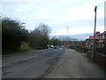
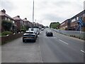
B6096 Road in Hoyland
Seen here approaching a mini roundabout which continues along Wombwell Road or alternatively turns right onto Market Street.
Image: © Jonathan Clitheroe
Taken: 17 Feb 2017
0.16 miles

7
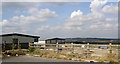
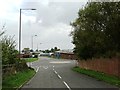
Newly constructed factory / warehouse units.
Built very near to some large residential properties.
Image: © Steve Fareham
Taken: 11 Sep 2007
0.21 miles
10

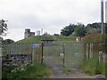
The Hoyland Lowe Stand
18th Century folly built by the Marquis of Rockingham and likely to have been originally conceived as a hunting lodge. Situated a good 3 miles from Wentworth Woodhouse it would have probably have been overlooked by the estate in favour of nearer amenities and today the stand is in a fairly advanced state of decay. Originally a two storey structure, the top part of the winding staircase to the viewing platform can still be seen from inside the building.
Image: © Jonathan Clitheroe
Taken: 12 Jul 2008
0.24 miles