IMAGES TAKEN NEAR TO
Broad Carr Road, BARNSLEY, S74 9BS
Introduction
This page details the photographs taken nearby to Broad Carr Road, S74 9BS by members of the Geograph project.
The Geograph project started in 2005 with the aim of publishing, organising and preserving representative images for every square kilometre of Great Britain, Ireland and the Isle of Man.

There are currently over 7.5m images from over14,400 individuals and you can help contribute to the project by visiting https://www.geograph.org.uk
Image Map
Images are licensed for reuse under creativecommons.org/licenses/by-sa/2.0
Notes
- Clicking on the map will re-center to the selected point.
- The higher the marker number, the further away the image location is from the centre of the postcode.
Image Listing (8 Images Found)
Images are licensed for reuse under creativecommons.org/licenses/by-sa/2.0
Image
Details
Distance
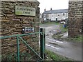
3
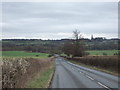
Alderthwaite
Farm at the intersection of Broadcarr Road and Burying Lane.
Image: © Roger May
Taken: 13 Mar 2006
0.04 miles
4
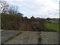
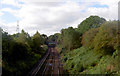
Railway line towards Hoyland.
A peep over the bridge
Image: © steven ruffles
Taken: 15 Feb 2012
0.10 miles
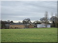
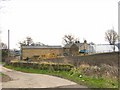
7
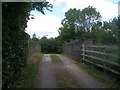
Bridge over the railway near Alderthwaite Farm
Image: © John Slater
Taken: 6 Jun 2019
0.14 miles
8
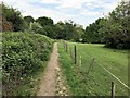
Footpath in Skier's Spring Wood
Wooded area interspersed with fields pictured at the eastern edge of the square to the south of Hoyland. This path also forms part of the Barnsley Boundary Walk.
Image: © Jonathan Clitheroe
Taken: 23 May 2019
0.23 miles