IMAGES TAKEN NEAR TO
Valley Drive, BARNSLEY, S74 9BL
Introduction
This page details the photographs taken nearby to Valley Drive, S74 9BL by members of the Geograph project.
The Geograph project started in 2005 with the aim of publishing, organising and preserving representative images for every square kilometre of Great Britain, Ireland and the Isle of Man.

There are currently over 7.5m images from over14,400 individuals and you can help contribute to the project by visiting https://www.geograph.org.uk
Image Map
Images are licensed for reuse under creativecommons.org/licenses/by-sa/2.0
Notes
- Clicking on the map will re-center to the selected point.
- The higher the marker number, the further away the image location is from the centre of the postcode.
Image Listing (25 Images Found)
Images are licensed for reuse under creativecommons.org/licenses/by-sa/2.0
Image
Details
Distance
1

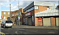
Hoyland - builders merchants on West Street
Image: © Dave Bevis
Taken: 30 Oct 2013
0.16 miles
2

Hoyland Family Dental Centre, #17 Milton Road
Image: © Roger Templeman
Taken: 14 Aug 2018
0.17 miles
3
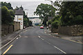
West Street, Hoyland
East towards The Hoyland Centre.
Image: © J.Hannan-Briggs
Taken: 15 Jun 2014
0.17 miles
5
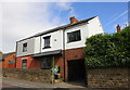
#67 and #65 West Street
These houses appear to have been rebuilt or extended
Image: © Roger Templeman
Taken: 14 Aug 2018
0.19 miles
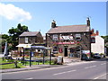
10
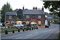
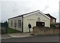
The Furnace public house, Milton, near Elsecar
Opposite the site of Milton Ironworks, hence the name.
Image: © Chris Allen
Taken: 11 May 2017
0.21 miles