IMAGES TAKEN NEAR TO
The Croft, BARNSLEY, S74 8EB
Introduction
This page details the photographs taken nearby to The Croft, S74 8EB by members of the Geograph project.
The Geograph project started in 2005 with the aim of publishing, organising and preserving representative images for every square kilometre of Great Britain, Ireland and the Isle of Man.

There are currently over 7.5m images from over14,400 individuals and you can help contribute to the project by visiting https://www.geograph.org.uk
Image Map
Images are licensed for reuse under creativecommons.org/licenses/by-sa/2.0
Notes
- Clicking on the map will re-center to the selected point.
- The higher the marker number, the further away the image location is from the centre of the postcode.
Image Listing (115 Images Found)
Images are licensed for reuse under creativecommons.org/licenses/by-sa/2.0
Image
Details
Distance
1
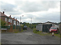
Bridleway to Milton
The straightness of this lane reflects the fact that it was originally a tramway inclined plane, connecting Milton Ironworks with the canal at Elsecar basin.
Image: © Alan Murray-Rust
Taken: 13 Sep 2009
0.03 miles
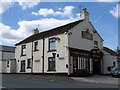
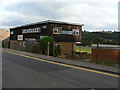
4
Crown Garage
This rather brash building is out of character with its stone built neighbours, but nevertheless has some interesting features, in particular the British-Leyland-Morris sign.
Image: © Alan Murray-Rust
Taken: 13 Sep 2009
0.07 miles
5
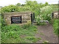
Bridleway between Elsecar & Milton
The plaque reads:- The inclined plane. Laid from Milton ironworks to Elsecar canal basin c1840. Transported 500 wagons per day. Finally dismantled c1930. Plaque presented by CEP
Image: © trevor willis
Taken: 17 May 2008
0.08 miles
7
Elsecar Main Sports
Overlooking the cricket ground on Armroyd Lane. Elsecar Main was the name of the local colliery.
Image: © Alan Murray-Rust
Taken: 13 Sep 2009
0.09 miles
8
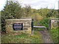
The Inclined Plane
Footpath that now runs along the former rope-hauled inclined tramway between Milton Ironworks and Elsecar canal basin.
Image: © Dave Taylor
Taken: 11 Oct 2009
0.09 miles
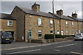
9
56-64 Fitzwilliam Street
Probably built at around the same time as the neighbouring Fitzwilliam Lodge http://www.geograph.org.uk/photo/1505603, i.e. around 1850.
Image: © Alan Murray-Rust
Taken: 13 Sep 2009
0.10 miles
10

56-64 Fitzwilliam Street
Probably built at around the same time as the neighbouring Fitzwilliam Lodge http://www.geograph.org.uk/photo/1505603, I.e. around 1850. Note also The George V wallbox (ref S74 31) built into a freestanding brick pillar.
Image: © Alan Murray-Rust
Taken: 13 Sep 2009
0.10 miles