IMAGES TAKEN NEAR TO
Woodhead Mews, BARNSLEY, S74 0RH
Introduction
This page details the photographs taken nearby to Woodhead Mews, S74 0RH by members of the Geograph project.
The Geograph project started in 2005 with the aim of publishing, organising and preserving representative images for every square kilometre of Great Britain, Ireland and the Isle of Man.

There are currently over 7.5m images from over14,400 individuals and you can help contribute to the project by visiting https://www.geograph.org.uk
Image Map
Images are licensed for reuse under creativecommons.org/licenses/by-sa/2.0
Notes
- Clicking on the map will re-center to the selected point.
- The higher the marker number, the further away the image location is from the centre of the postcode.
Image Listing (16 Images Found)
Images are licensed for reuse under creativecommons.org/licenses/by-sa/2.0
Image
Details
Distance


5
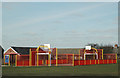
Basketball court at Blacker Hill
A brightly-coloured court in the corner of a recreation ground.
Image: © Chris Yeates
Taken: 22 Mar 2006
0.10 miles

7
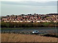
Looking over Blacker Hill
Across the A6195 M1-A1(M) link road from a footpath in Platts Common .
Image: © Graham Hogg
Taken: 18 Jan 2012
0.13 miles