IMAGES TAKEN NEAR TO
Blacker Hill Sidings, BARNSLEY, S74 0RE
Introduction
This page details the photographs taken nearby to Blacker Hill Sidings, S74 0RE by members of the Geograph project.
The Geograph project started in 2005 with the aim of publishing, organising and preserving representative images for every square kilometre of Great Britain, Ireland and the Isle of Man.

There are currently over 7.5m images from over14,400 individuals and you can help contribute to the project by visiting https://www.geograph.org.uk
Image Map
Images are licensed for reuse under creativecommons.org/licenses/by-sa/2.0
Notes
- Clicking on the map will re-center to the selected point.
- The higher the marker number, the further away the image location is from the centre of the postcode.
Image Listing (6 Images Found)
Images are licensed for reuse under creativecommons.org/licenses/by-sa/2.0
Image
Details
Distance
2
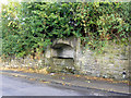
Ornate arched window alongside disused railway line
This piece of decorative stonework was rescued from the now demolished Blacker Hill Methodist Chapel and relaid here jigsaw style by local workmen with the help of a photo supplied by a site agent. The lettering around the arch reads 'Primitive Methodist Chapel'. Thanks to Phil for the additional information - he worked on this project and recalls this window being relaid in the late nineties.
Image: © Jonathan Clitheroe
Taken: 12 Oct 2008
0.07 miles


5

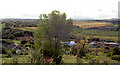
Wentworth Road
Leaving Blacker Hill heading north east.
Image: © JThomas
Taken: 27 Sep 2014
0.16 miles