IMAGES TAKEN NEAR TO
Parkside Road, BARNSLEY, S74 0AL
Introduction
This page details the photographs taken nearby to Parkside Road, S74 0AL by members of the Geograph project.
The Geograph project started in 2005 with the aim of publishing, organising and preserving representative images for every square kilometre of Great Britain, Ireland and the Isle of Man.

There are currently over 7.5m images from over14,400 individuals and you can help contribute to the project by visiting https://www.geograph.org.uk
Image Map
Images are licensed for reuse under creativecommons.org/licenses/by-sa/2.0
Notes
- Clicking on the map will re-center to the selected point.
- The higher the marker number, the further away the image location is from the centre of the postcode.
Image Listing (5 Images Found)
Images are licensed for reuse under creativecommons.org/licenses/by-sa/2.0
Image
Details
Distance

3
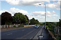
Sheffield Road, Hoyland
The former A6135 passing Hoyland. A new road has been built servicing the Evri distribution shed.
Image: © Richard Webb
Taken: 30 May 2023
0.22 miles
4
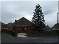
B6096 Hoyland Road and Monkey Puzzle tree
Image: © J.Hannan-Briggs
Taken: 15 Jun 2014
0.24 miles