IMAGES TAKEN NEAR TO
Venetian Crescent, BARNSLEY, S73 9PZ
Introduction
This page details the photographs taken nearby to Venetian Crescent, S73 9PZ by members of the Geograph project.
The Geograph project started in 2005 with the aim of publishing, organising and preserving representative images for every square kilometre of Great Britain, Ireland and the Isle of Man.

There are currently over 7.5m images from over14,400 individuals and you can help contribute to the project by visiting https://www.geograph.org.uk
Image Map
Images are licensed for reuse under creativecommons.org/licenses/by-sa/2.0
Notes
- Clicking on the map will re-center to the selected point.
- The higher the marker number, the further away the image location is from the centre of the postcode.
Image Listing (26 Images Found)
Images are licensed for reuse under creativecommons.org/licenses/by-sa/2.0
Image
Details
Distance
1

Allotment gardens - Low Valley
A view of the allotment gardens to the rear of Pit Street - Low Valley Darfield. The roof of the old snooker club is just visible to the far left of the picture.
Image: © Jeff Pearson
Taken: 5 May 2007
0.06 miles
2
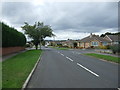
Upperwood Road, Darfield
Heading north west.
Image: © JThomas
Taken: 27 Sep 2014
0.08 miles
3
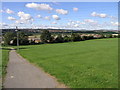
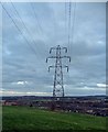
Clouds and Cables
The path is a public footpath that runs down Snape Hill.
Image: © Michael Patterson
Taken: 7 Sep 2006
0.09 miles
4
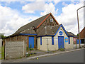
Temple Gym.
Now closed, formerly a church, notice damage to roof where lead has been stolen.
Another member stated on 30 September 2007: This old church has now been demolished.
Image: © Steve Fareham
Taken: 22 Jul 2007
0.11 miles
5
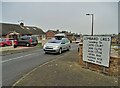
Lombard Crescent, Darfield
On this private housing estate west of Darfield, the streets are curiously named after places in Italy.
Image: © Neil Theasby
Taken: 13 Nov 2022
0.12 miles
6
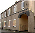
Derelict flats in a regeneration area.
This building used to be a shop and beer off.
Image: © Steve Fareham
Taken: 15 Aug 2007
0.14 miles
7
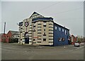
Former cinema, Darfield
The purpose-built Briton Picture House only operated as a cinema for a few years around the time of World War One. Later it served other purposes - including storage facility, roller skating rink, dance hall and snooker club. Currently it is an emporium for anglers.
Image: © Neil Theasby
Taken: 13 Nov 2022
0.15 miles
8
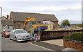
Demolition of Temple Gym (former church).
Image: © Steve Fareham
Taken: 2 Sep 2007
0.15 miles
10

Dearne Valley sunset (well over Wombwell) from Roundwood Way Darfield
After a day of rain (yet another!) the sky broke and a vivid sunset lasted a whole 5 minutes.
Image: © Steve Fareham
Taken: 29 Dec 2012
0.16 miles