IMAGES TAKEN NEAR TO
Padua Rise, BARNSLEY, S73 9PQ
Introduction
This page details the photographs taken nearby to Padua Rise, S73 9PQ by members of the Geograph project.
The Geograph project started in 2005 with the aim of publishing, organising and preserving representative images for every square kilometre of Great Britain, Ireland and the Isle of Man.

There are currently over 7.5m images from over14,400 individuals and you can help contribute to the project by visiting https://www.geograph.org.uk
Image Map
Images are licensed for reuse under creativecommons.org/licenses/by-sa/2.0
Notes
- Clicking on the map will re-center to the selected point.
- The higher the marker number, the further away the image location is from the centre of the postcode.
Image Listing (26 Images Found)
Images are licensed for reuse under creativecommons.org/licenses/by-sa/2.0
Image
Details
Distance
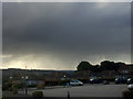
1

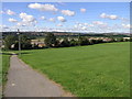
Rainbow over the Dearne Valley
From Roundwood Way Darfield with Wombwell in the sunlight.
Image: © Steve Fareham
Taken: 20 Aug 2008
0.08 miles
2
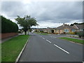
Upperwood Road, Darfield
Heading north west.
Image: © JThomas
Taken: 27 Sep 2014
0.09 miles
5

Dearne Valley sunset (well over Wombwell) from Roundwood Way Darfield
After a day of rain (yet another!) the sky broke and a vivid sunset lasted a whole 5 minutes.
Image: © Steve Fareham
Taken: 29 Dec 2012
0.11 miles
6
As we say in Yorkshire It's black over Bill's Mother's
Image: © Steve Fareham
Taken: 25 Sep 2016
0.12 miles
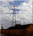
8
Clouds and Cables
The path is a public footpath that runs down Snape Hill.
Image: © Michael Patterson
Taken: 7 Sep 2006
0.12 miles
9
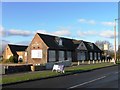
Closed: The Longbow Darfield
The co-op shop nearby are hoping to turn this into a new convenience store although CAMRA are opposing this.
Image: © Steve Fareham
Taken: 13 Jan 2013
0.13 miles
10

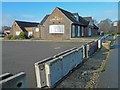
The Cooperative store on Bly Road
Originally a corner shop run by the Winder family built I think when the housing estate was built around 1949, it has had a series of owners and modifications over the years.
Image: © Steve Fareham
Taken: 13 Jan 2013
0.14 miles