IMAGES TAKEN NEAR TO
Inkerman Road, BARNSLEY, S73 9ND
Introduction
This page details the photographs taken nearby to Inkerman Road, S73 9ND by members of the Geograph project.
The Geograph project started in 2005 with the aim of publishing, organising and preserving representative images for every square kilometre of Great Britain, Ireland and the Isle of Man.

There are currently over 7.5m images from over14,400 individuals and you can help contribute to the project by visiting https://www.geograph.org.uk
Image Map
Images are licensed for reuse under creativecommons.org/licenses/by-sa/2.0
Notes
- Clicking on the map will re-center to the selected point.
- The higher the marker number, the further away the image location is from the centre of the postcode.
Image Listing (58 Images Found)
Images are licensed for reuse under creativecommons.org/licenses/by-sa/2.0
Image
Details
Distance
1

Barnsley Road Darfield just north of the Inkerman.
Image: © Steve Fareham
Taken: 13 Aug 2007
0.04 miles
3
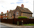
The Nurses Home.
The Nurse for Darfield used to live here.
Image: © Steve Fareham
Taken: 13 Aug 2007
0.06 miles
4
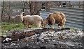
Mountain Goats?
No goats grazing near the allotments on College Terrace.
Image: © Steve Fareham
Taken: 19 Mar 2008
0.08 miles
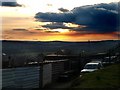
5
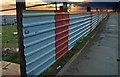
Allotment fencing
Sunset over the plastisol sheeted industrial roofing fence to allotments on College Terrace/ South View Darfield.
Image: © Steve Fareham
Taken: 19 Mar 2008
0.09 miles
7

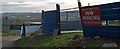
Why?
Someone's pride and joy trashed on Inkerman Fields Darfield.
Image: © Steve Fareham
Taken: 24 Dec 2016
0.13 miles
8
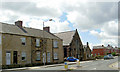
Darfield top chapel.
Darfield Wesley chapel.
Image: © Steve Fareham
Taken: 22 Jul 2007
0.13 miles
10
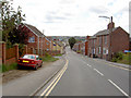
Zooming down Snape Hill.
Road to Wombwell from Darfield.
Image: © Steve Fareham
Taken: 22 Jul 2007
0.15 miles