IMAGES TAKEN NEAR TO
Cliff Road, BARNSLEY, S73 9HP
Introduction
This page details the photographs taken nearby to Cliff Road, S73 9HP by members of the Geograph project.
The Geograph project started in 2005 with the aim of publishing, organising and preserving representative images for every square kilometre of Great Britain, Ireland and the Isle of Man.

There are currently over 7.5m images from over14,400 individuals and you can help contribute to the project by visiting https://www.geograph.org.uk
Image Map
Images are licensed for reuse under creativecommons.org/licenses/by-sa/2.0
Notes
- Clicking on the map will re-center to the selected point.
- The higher the marker number, the further away the image location is from the centre of the postcode.
Image Listing (46 Images Found)
Images are licensed for reuse under creativecommons.org/licenses/by-sa/2.0
Image
Details
Distance
1

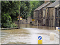
Cliffe Road Darfield flooded for second time in 10 days
Image: © Joan Fareham
Taken: 26 Jun 2007
0.02 miles
2
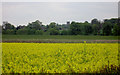
Rape crop Darfield.
Darfield church on skyline.
Image: © Steve Fareham
Taken: 8 May 2004
0.05 miles
3

Riverside Close flooded by River Dearne
Image: © Steve Fareham
Taken: 16 Jun 2007
0.06 miles
4
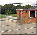
Darfield Army Cadets rifle range.
Recently flooded on Cliff Road.
Image: © Steve Fareham
Taken: 17 Aug 2007
0.07 miles

7
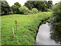
Back to normal.
The River Dearne back to its normal levels. Compare recent photos where the water was above the measuring level causing havoc to cliff road in Darfield.
Image: © Steve Fareham
Taken: 17 Aug 2007
0.08 miles

9
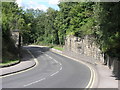
Missing Bridge
The railway and bridge have long gone but the walls that once supported the bridge will be around for a few more years.
Image: © Michael Patterson
Taken: 7 Sep 2006
0.09 miles
10
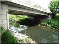
Mill Houses Bridge over the River Dearne
Image: © Neil Theasby
Taken: 21 May 2015
0.09 miles