IMAGES TAKEN NEAR TO
Shroggs Head Close, BARNSLEY, S73 9EW
Introduction
This page details the photographs taken nearby to Shroggs Head Close, S73 9EW by members of the Geograph project.
The Geograph project started in 2005 with the aim of publishing, organising and preserving representative images for every square kilometre of Great Britain, Ireland and the Isle of Man.

There are currently over 7.5m images from over14,400 individuals and you can help contribute to the project by visiting https://www.geograph.org.uk
Image Map
Images are licensed for reuse under creativecommons.org/licenses/by-sa/2.0
Notes
- Clicking on the map will re-center to the selected point.
- The higher the marker number, the further away the image location is from the centre of the postcode.
Image Listing (121 Images Found)
Images are licensed for reuse under creativecommons.org/licenses/by-sa/2.0
Image
Details
Distance
1
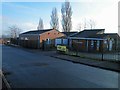
Darfield Children's Centre, Shroggs Head
The site of this centre and the cluster of bungalow's belonging in whole or part to the housing association Guinness Northern Counties, was a former infants School.
The bungalows were first occupied in 1993.
Image: © Steve Fareham
Taken: 13 Jan 2013
0.03 miles
2
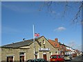
Darfield Conservative Club
Flag is at half mast as a mark of respect for a member who has just died. Next door is Amy's (was Gordon's) fish and chip shop.
Image: © Steve Fareham
Taken: 30 Mar 2008
0.04 miles
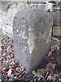
4
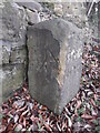
Old milestone
This milestone is on Doncaster Road in Darfield, just east of Nanny Marr Road. It is slightly higher up the hill than the European War Memorial. On the left face is inscribed PON/12M/Houghton. That is the very old packhorse route that would have forded the River Dearne, now bridged, to reach Houghton, then north to eventually arrive at Pontefract.
Image: © Chris Minto
Taken: 17 Feb 2018
0.04 miles
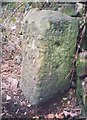
5
Old milestone
The front face of the very old milestone on the hill in Darfield is inscribed DON/10M/?IXX. What does that mean? The right face had something now indecipherable with PON/12M near the base. The very narrow paved lane leads down to the River Dearne and is part of the packhorse route from Sheffield to Pontefract. This stone is Grade II listed 1315019.
Image: © Chris Minto
Taken: 17 Feb 2018
0.04 miles
6
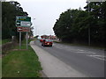
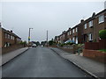
Doncaster Road (A635)
Heading west towards Barnsley.
Image: © JThomas
Taken: 25 Sep 2013
0.04 miles
8
Old Milestone, A635, Doncaster Road
Darfield opp Middlewood Hall. Located on the South side of road, next to stone wall, down hill, just east of Nanny Marr Road, above European War Memorial. Carved stone post, 18th century.
Inscription reads: PON / 12M / Houghton // DON / 10M / (?IXX) // ? / PON / 12 M
Grade II listed by Historic England. see https://historicengland.org.uk/listing/the-list/list-entry/1315019
Milestone Society National ID: YS_DNBN10a
Image: © Christine Minto
Taken: 28 Jan 2021
0.05 miles
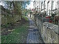
10
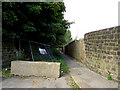
Is the bridleway open or closed?
Heras fencing closing bridleway erected a couple of days ago now down or is it?
Image: © Steve Fareham
Taken: 25 Aug 2007
0.06 miles