IMAGES TAKEN NEAR TO
Bellbrooke Close, BARNSLEY, S73 9BU
Introduction
This page details the photographs taken nearby to Bellbrooke Close, S73 9BU by members of the Geograph project.
The Geograph project started in 2005 with the aim of publishing, organising and preserving representative images for every square kilometre of Great Britain, Ireland and the Isle of Man.

There are currently over 7.5m images from over14,400 individuals and you can help contribute to the project by visiting https://www.geograph.org.uk
Image Map
Images are licensed for reuse under creativecommons.org/licenses/by-sa/2.0
Notes
- Clicking on the map will re-center to the selected point.
- The higher the marker number, the further away the image location is from the centre of the postcode.
Image Listing (23 Images Found)
Images are licensed for reuse under creativecommons.org/licenses/by-sa/2.0
Image
Details
Distance
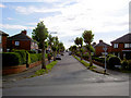
3
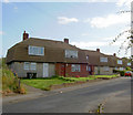
Cornish houses.
Why are these called Cornish houses?
Image: © Steve Fareham
Taken: 6 Aug 2007
0.04 miles
4
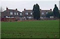
Derelict 'Cornish' houses on Belbrooke Avenue
System built (1950's) council housing now in total disrepair.
Image: © Steve Fareham
Taken: 1 Jan 2009
0.06 miles
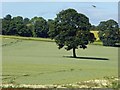
6
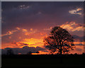
Tree at Sunset looking towards Edderthorpe
Image: © Steve Fareham
Taken: 31 Mar 2007
0.10 miles
7
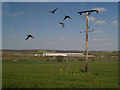
Duck!
Ducks in front of power cables and post with the new Prologis shed in the background.
Image: © Steve Fareham
Taken: 7 Apr 2007
0.11 miles
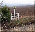
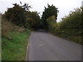
10
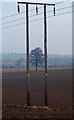
The lonely tree framed by power cable supports
From Edderthorpe Lane.
Image: © Steve Fareham
Taken: 1 Jan 2009
0.16 miles