IMAGES TAKEN NEAR TO
Pit Lane, BARNSLEY, S73 8UF
Introduction
This page details the photographs taken nearby to Pit Lane, S73 8UF by members of the Geograph project.
The Geograph project started in 2005 with the aim of publishing, organising and preserving representative images for every square kilometre of Great Britain, Ireland and the Isle of Man.

There are currently over 7.5m images from over14,400 individuals and you can help contribute to the project by visiting https://www.geograph.org.uk
Image Map
Images are licensed for reuse under creativecommons.org/licenses/by-sa/2.0
Notes
- Clicking on the map will re-center to the selected point.
- The higher the marker number, the further away the image location is from the centre of the postcode.
Image Listing (10 Images Found)
Images are licensed for reuse under creativecommons.org/licenses/by-sa/2.0
Image
Details
Distance
2
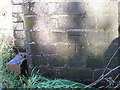
Benchmark on Summer Lane railway bridge, Wombwell
Image: © John Slater
Taken: 23 Nov 2012
0.03 miles
3
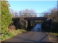
Summer Lane railway bridge
The benchmark at Image can be found on the northwest side of the road, southwest side of the railway (left side of road, this side of railway in this photo)
Image: © John Slater
Taken: 23 Nov 2012
0.04 miles
5
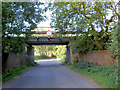
Bridge carrying Leeds to Sheffield railway line.
Image: © Steve Fareham
Taken: 7 Sep 2007
0.06 miles
6
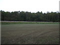
Woodland beyond Sheffield to Barnsley Railway
View from near Dovecliffe Road.
Image: © JThomas
Taken: 27 Sep 2014
0.10 miles
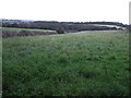
8
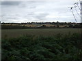
Farmland towards Wombwell
Off Dovecliffe Road.
Image: © JThomas
Taken: 27 Sep 2014
0.20 miles
10

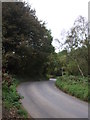
Towards Smithley from Dovecliffe Road
View from the edge of Wombwell Wood.
Image: © Jonathan Clitheroe
Taken: 4 Jul 2015
0.23 miles