IMAGES TAKEN NEAR TO
Summer Lane, BARNSLEY, S73 8TU
Introduction
This page details the photographs taken nearby to Summer Lane, S73 8TU by members of the Geograph project.
The Geograph project started in 2005 with the aim of publishing, organising and preserving representative images for every square kilometre of Great Britain, Ireland and the Isle of Man.

There are currently over 7.5m images from over14,400 individuals and you can help contribute to the project by visiting https://www.geograph.org.uk
Image Map
Images are licensed for reuse under creativecommons.org/licenses/by-sa/2.0
Notes
- Clicking on the map will re-center to the selected point.
- The higher the marker number, the further away the image location is from the centre of the postcode.
Image Listing (10 Images Found)
Images are licensed for reuse under creativecommons.org/licenses/by-sa/2.0
Image
Details
Distance
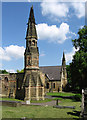
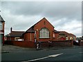
2
Wombwell - Methodist Church and Hall
On Summer Lane.
Image: © Dave Bevis
Taken: 31 May 2013
0.16 miles
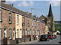
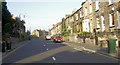
3

Summer Lane, Wombwell (2)
Looking towards the cemetery as it passes Melville Street allotments (right).
Image: © Richard Vince
Taken: 6 Jan 2024
0.19 miles
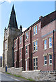
4
Wombwell - York Street and former Methodist church
Image: © Dave Bevis
Taken: 31 May 2013
0.19 miles
5

Wombwell - Pentecostal Church
On Cemetery Road.
Image: © Dave Bevis
Taken: 31 May 2013
0.21 miles
6

Wombwell - former Methodist church - Barnsley Road frontage
Image: © Dave Bevis
Taken: 31 May 2013
0.22 miles
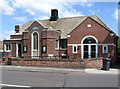
7

Wombwell - general store at High Street junction
With Cemetery Road.
Image: © Dave Bevis
Taken: 31 May 2013
0.23 miles
8
Wombwell - former Methodist church - Lower York Street frontage
Image: © Dave Bevis
Taken: 31 May 2013
0.23 miles
10
Wesleyan Reform Church
On Hough Lane. Stones above the doorway date the building to 1934.
Image: © Graham Hogg
Taken: 11 Jan 2012
0.24 miles