IMAGES TAKEN NEAR TO
Rose Place, BARNSLEY, S73 8NF
Introduction
This page details the photographs taken nearby to Rose Place, S73 8NF by members of the Geograph project.
The Geograph project started in 2005 with the aim of publishing, organising and preserving representative images for every square kilometre of Great Britain, Ireland and the Isle of Man.

There are currently over 7.5m images from over14,400 individuals and you can help contribute to the project by visiting https://www.geograph.org.uk
Image Map
Images are licensed for reuse under creativecommons.org/licenses/by-sa/2.0
Notes
- Clicking on the map will re-center to the selected point.
- The higher the marker number, the further away the image location is from the centre of the postcode.
Image Listing (35 Images Found)
Images are licensed for reuse under creativecommons.org/licenses/by-sa/2.0
Image
Details
Distance
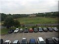
3
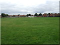
Playing fields, Wombwell
East of Aldham House Lane.
Image: © JThomas
Taken: 27 Sep 2014
0.18 miles
4
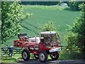
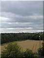
The cereal crop has been sprayed
An odd shaped field alongside the Wombwell by pass.
Image: © Steve Fareham
Taken: 2 Jun 2011
0.19 miles
5
14m tall conifer trees uprooted in storm.
Huge winds tore through the area in the afternoon.
Image: © Steve Fareham
Taken: 18 Jan 2007
0.19 miles
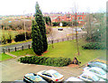
6

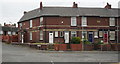
Billington Structures offices Wombwell
Image: © Steve Fareham
Taken: 27 Dec 2014
0.19 miles
7
Planning permission for a Lidl supermarket has been applied for on this green belt agricultural field
Image: © Steve Fareham
Taken: 8 Sep 2015
0.19 miles
8

Billington Structures office block glows in the early morning sun
Image: © Steve Fareham
Taken: 25 Jan 2016
0.19 miles
9
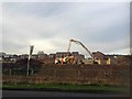
Persimmon homes being built on what was farmland Wombwell
Image: © Steve Fareham
Taken: 25 Jan 2016
0.19 miles