IMAGES TAKEN NEAR TO
Glenmore Rise, BARNSLEY, S73 0RP
Introduction
This page details the photographs taken nearby to Glenmore Rise, S73 0RP by members of the Geograph project.
The Geograph project started in 2005 with the aim of publishing, organising and preserving representative images for every square kilometre of Great Britain, Ireland and the Isle of Man.

There are currently over 7.5m images from over14,400 individuals and you can help contribute to the project by visiting https://www.geograph.org.uk
Image Map
Images are licensed for reuse under creativecommons.org/licenses/by-sa/2.0
Notes
- Clicking on the map will re-center to the selected point.
- The higher the marker number, the further away the image location is from the centre of the postcode.
Image Listing (5 Images Found)
Images are licensed for reuse under creativecommons.org/licenses/by-sa/2.0
Image
Details
Distance
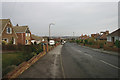
2
The south-east edge of Wombwell
The houses are on Dove Road, just north of the Eslecar branch of the Dearne & Dove Canal.
Image: © Christine Johnstone
Taken: 5 Feb 2017
0.15 miles
3

Canalside houses in Grantley Close
On the north bank of the Elsecar branch of the Dearne & Dove Canal. The canal was built to carry coal from local collieries. It had opened by 1798, at least 30 years before any railway competition. It closed to traffic [due to mining subsidence] in 1928. It was officially closed in 1961. The towpath is well used and a local group is keen to restore the canal.
Image: © Christine Johnstone
Taken: 5 Feb 2017
0.22 miles
4
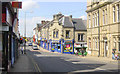
Wombwell
Looking north-west along High Street, Wombwell, South Yorkshire, from the corner of Church Street.
Image: © Martin Clark
Taken: Unknown
0.23 miles
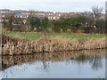
5

The Brampton Canal
More properly known as the Elsecar Branch of the Dearne and Dove Canal which linked the River Don Navigation with the Barnsley Canal. The Elsecar branch was built to serve the coal mines and so went past many of them. Although no longer navigable much of the canal remains in water and there are plans to restore it.
Image: © Graham Hogg
Taken: 18 Nov 2011
0.23 miles