IMAGES TAKEN NEAR TO
Lundhill Road, BARNSLEY, S73 0RA
Introduction
This page details the photographs taken nearby to Lundhill Road, S73 0RA by members of the Geograph project.
The Geograph project started in 2005 with the aim of publishing, organising and preserving representative images for every square kilometre of Great Britain, Ireland and the Isle of Man.

There are currently over 7.5m images from over14,400 individuals and you can help contribute to the project by visiting https://www.geograph.org.uk
Image Map
Images are licensed for reuse under creativecommons.org/licenses/by-sa/2.0
Notes
- Clicking on the map will re-center to the selected point.
- The higher the marker number, the further away the image location is from the centre of the postcode.
Image Listing (7 Images Found)
Images are licensed for reuse under creativecommons.org/licenses/by-sa/2.0
Image
Details
Distance
2
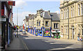
Wombwell
Looking north-west along High Street, Wombwell, South Yorkshire, from the corner of Church Street.
Image: © Martin Clark
Taken: Unknown
0.07 miles
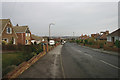
4
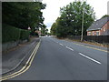
Park Street
Heading north west into Wombwell.
Image: © JThomas
Taken: 27 Sep 2014
0.13 miles
5
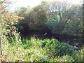
Disused Canal near Valley Way
The Dearne and Dove Canal is all but lost amid the new roads and developments in this area but it can be seen here by a grassy clearing close to the A633.
Image: © Jonathan Clitheroe
Taken: 7 Oct 2011
0.15 miles
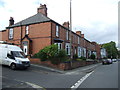
6
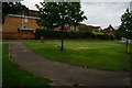
Houses on Wath Road
Taken from Brampton Road.
Image: © Ian S
Taken: 31 May 2014
0.16 miles