IMAGES TAKEN NEAR TO
Hart Hills, BARNSLEY, S73 0QX
Introduction
This page details the photographs taken nearby to Hart Hills, S73 0QX by members of the Geograph project.
The Geograph project started in 2005 with the aim of publishing, organising and preserving representative images for every square kilometre of Great Britain, Ireland and the Isle of Man.

There are currently over 7.5m images from over14,400 individuals and you can help contribute to the project by visiting https://www.geograph.org.uk
Image Map
Images are licensed for reuse under creativecommons.org/licenses/by-sa/2.0
Notes
- Clicking on the map will re-center to the selected point.
- The higher the marker number, the further away the image location is from the centre of the postcode.
Image Listing (15 Images Found)
Images are licensed for reuse under creativecommons.org/licenses/by-sa/2.0
Image
Details
Distance
1
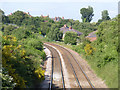
Midland Railway Chapeltown Extension Railway
Looking north at Hemingfield Cemetery Road bridge. The railway was built at a relatively late date - 1893-95 - to tap the rapidly developing coal industry in the area. It now provides an important passenger rail link between Sheffield and Leeds via Barnsley.
Image: © Alan Murray-Rust
Taken: 8 Jul 2013
0.04 miles
2
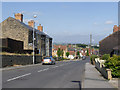
Cemetery Road, Hemingfield
Looking towards the centre of Hemingfield.
Image: © Alan Murray-Rust
Taken: 8 Jul 2013
0.08 miles
3
Cemetery Road railway bridge, Hemingfield
There is a bench mark cut into the parapet on the right hand side at this end of the bridge http://www.geograph.org.uk/photo/3549895 .
Image: © Alan Murray-Rust
Taken: 8 Jul 2013
0.11 miles
4
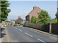
Bridge over railway line to Sheffield.
Image: © Steve Fareham
Taken: 11 Sep 2007
0.12 miles
5
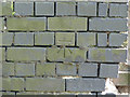
Bench Mark, Cemetery Road railway bridge, Hemingfield
Cut bench mark in the parapet of the bridge http://www.geograph.org.uk/photo/3549901 .
Image: © Alan Murray-Rust
Taken: 8 Jul 2013
0.12 miles
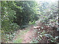
6
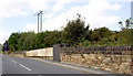
Footpath towards Wombwell Wood west of Hemingfield
Image: © John Slater
Taken: 28 Sep 2016
0.16 miles
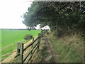
7
Footpath towards the railway tunnel at Hemingfield
Image: © John Slater
Taken: 28 Sep 2016
0.16 miles
8
Coronation Terrace, Hemingfield
This terrace does not appear on the 1903 OS map, but I would nevertheless put the Coronation in question to be that of Edward VII in 1901.
Image: © Alan Murray-Rust
Taken: 8 Jul 2013
0.17 miles
9
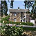
Stone cottage with roses, Hemingfield
The modern tiled roof does not sit too well with the traditional stonework.
Image: © Alan Murray-Rust
Taken: 8 Jul 2013
0.18 miles
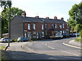
10
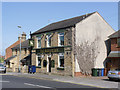
The Albion Inn
This dates back to the time when Hemingfield was still essentially an agricultural village.
Image: © Alan Murray-Rust
Taken: 8 Jul 2013
0.19 miles