IMAGES TAKEN NEAR TO
Hall Cross Avenue, BARNSLEY, S73 0NN
Introduction
This page details the photographs taken nearby to Hall Cross Avenue, S73 0NN by members of the Geograph project.
The Geograph project started in 2005 with the aim of publishing, organising and preserving representative images for every square kilometre of Great Britain, Ireland and the Isle of Man.

There are currently over 7.5m images from over14,400 individuals and you can help contribute to the project by visiting https://www.geograph.org.uk
Image Map
Images are licensed for reuse under creativecommons.org/licenses/by-sa/2.0
Notes
- Clicking on the map will re-center to the selected point.
- The higher the marker number, the further away the image location is from the centre of the postcode.
Image Listing (20 Images Found)
Images are licensed for reuse under creativecommons.org/licenses/by-sa/2.0
Image
Details
Distance
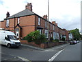
1
Houses on Wath Road
Taken from Brampton Road.
Image: © Ian S
Taken: 31 May 2014
0.03 miles
2
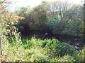
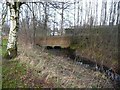
Disused Canal near Valley Way
The Dearne and Dove Canal is all but lost amid the new roads and developments in this area but it can be seen here by a grassy clearing close to the A633.
Image: © Jonathan Clitheroe
Taken: 7 Oct 2011
0.09 miles
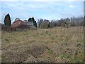
3
Flats on Junction Close, off Junction Street
Named after the junction of the Dearne & Dove Canal and its Elsecar branch {Wombwell Junction}, which was approximately just behind the photographer.
Image: © Christine Johnstone
Taken: 5 Feb 2017
0.09 miles
4
The Dearne & Dove Canal, west of Junction Bridge
The canal was built to carry coal from local collieries. It officially closed in 1961.
Image: © Christine Johnstone
Taken: 5 Feb 2017
0.11 miles
5
Junction Bridge
Carrying the A633 [Wath Road] over the remains of the Dearne & Dove Canal.
Image: © Christine Johnstone
Taken: 5 Feb 2017
0.11 miles
6
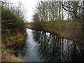
The route of the Elsecar Branch, Dearne & Dove Canal
Immediately south-west of its junction with the 'main line', but now completely infilled. The canal was built to carry coal from local collieries. It had opened by 1798, at least 30 years before any railway competition. It closed to traffic [due to mining subsidence] in 1928. It was officially closed in 1961. The towpath is well used by walkers and cyclists and a local group is keen to restore the canal.
Image: © Christine Johnstone
Taken: 5 Feb 2017
0.15 miles
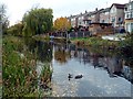
7
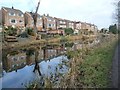
Brampton Crescent houses reflected in the Elsecar Branch
The canal was built to carry coal from local collieries. It had opened by 1798, at least 30 years before any railway competition. It closed to traffic [due to mining subsidence] in 1928. It was officially closed in 1961. The towpath is well used and a local group is keen to restore the canal.
Image: © Christine Johnstone
Taken: 5 Feb 2017
0.19 miles
8
Canal at Brampton.
Along the Barnsley boundary walk.
Image: © steven ruffles
Taken: 10 Feb 2012
0.20 miles
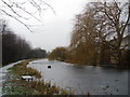
10
The Brampton Canal
More properly known as the Elsecar Branch of the Dearne and Dove Canal which linked the River Don Navigation with the Barnsley Canal. The Elsecar branch was built to serve the coal mines and so went past many of them. The majority of the towpath is on the Elsecar Greenway, part of the Trans Pennine Trail. Although no longer navigable much of the canal remains in water and there are plans to restore it.
Image: © Graham Hogg
Taken: 18 Nov 2011
0.22 miles